IMAGES TAKEN NEAR TO
Queensholm Crescent, BRISTOL, BS16 6LR
Introduction
This page details the photographs taken nearby to Queensholm Crescent, BS16 6LR by members of the Geograph project.
The Geograph project started in 2005 with the aim of publishing, organising and preserving representative images for every square kilometre of Great Britain, Ireland and the Isle of Man.

There are currently over 7.5m images from over14,400 individuals and you can help contribute to the project by visiting https://www.geograph.org.uk
Image Map
Images are licensed for reuse under creativecommons.org/licenses/by-sa/2.0
Notes
- Clicking on the map will re-center to the selected point.
- The higher the marker number, the further away the image location is from the centre of the postcode.
Image Listing (6 Images Found)
Images are licensed for reuse under creativecommons.org/licenses/by-sa/2.0
Image
Details
Distance
1
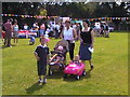
Bromley Heath Park summer fete 2003
Always get sunshine each year!
Image: © Tony Parker
Taken: Unknown
0.07 miles
2
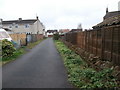
An older remnant of Bromley Heath Road
This little piece of road is still part of Bromley Heath Road and contains some older houses (behind the photographer) which have been surrounded by later development. All of them share the same street number as two houses on the main road, and they are distinguished from one another by a suffixed letter. Another remnant of the area as it was, is the drystone wall seen here.
Image: © HelenK
Taken: 19 Mar 2020
0.15 miles
3
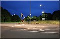
Winterbourne : Bromley Heath Roundabout
At the roundabout on the A4174.
Image: © Lewis Clarke
Taken: 10 Aug 2022
0.17 miles
4
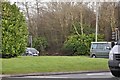
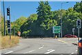
South Gloucestershire : Bromley Heath Roundabout
Looking over the grassy section of Bromley Heath Roundabout near Hambrook.
Image: © Lewis Clarke
Taken: 1 Feb 2013
0.17 miles
5
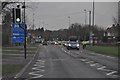
Bristol : Bromley Heath Road
Bromley Heath Road leading to Bromley Heath Roundabout.
Image: © Lewis Clarke
Taken: 1 Feb 2013
0.20 miles