IMAGES TAKEN NEAR TO
Bromley Heath Road, BRISTOL, BS16 6JU
Introduction
This page details the photographs taken nearby to Bromley Heath Road, BS16 6JU by members of the Geograph project.
The Geograph project started in 2005 with the aim of publishing, organising and preserving representative images for every square kilometre of Great Britain, Ireland and the Isle of Man.

There are currently over 7.5m images from over14,400 individuals and you can help contribute to the project by visiting https://www.geograph.org.uk
Image Map
Images are licensed for reuse under creativecommons.org/licenses/by-sa/2.0
Notes
- Clicking on the map will re-center to the selected point.
- The higher the marker number, the further away the image location is from the centre of the postcode.
Image Listing (23 Images Found)
Images are licensed for reuse under creativecommons.org/licenses/by-sa/2.0
Image
Details
Distance
1
Pipes over the Frome
Some heavy pipework, with a few smaller deletions, spanning the River Frome.
Image: © Neil Owen
Taken: 25 May 2019
0.06 miles
2
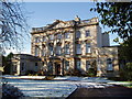
Frenchay Manor House
Palladian style house built c.1736 for Joseph Beck, a wealthy Quaker merchant.
Image: © Don Ford
Taken: 25 Nov 2005
0.07 miles
3
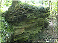
River-worn rocks
The local stone is sedimentary and the erosion of millennia shows it nicely.
Image: © Neil Owen
Taken: 25 May 2019
0.09 miles
4
Frome Valley tranquillity and thunder
The Frome Valley Walkway at Hambrook where the path goes under the noisy M4 just east of the junction with the M32 to Bristol centre
Image: © John Phillips
Taken: 13 Sep 2005
0.11 miles
6
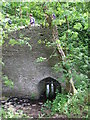
Bridging the brook
A small bridge with very high parapets.
Image: © Neil Owen
Taken: 25 May 2019
0.12 miles
7
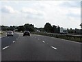
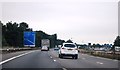
South Gloucestershire : M4 Motorway
The M4 Motorway between Junction 19 (Hambrook Interchange) and Junction 18 (Tormarton Interchange).
Image: © Lewis Clarke
Taken: 23 Mar 2018
0.12 miles
8
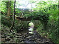
Old bridge near Hambrook
A very tall packhorse bridge, dated around the seventeenth century. It is certainly very tall but narrow.
Image: © Neil Owen
Taken: 25 May 2019
0.13 miles
10
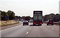
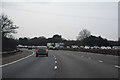
M4 bends to the left
At Marker B180.8
Image: © J.Hannan-Briggs
Taken: 30 Jul 2014
0.15 miles