IMAGES TAKEN NEAR TO
Downend Park Road, BRISTOL, BS16 5SZ
Introduction
This page details the photographs taken nearby to Downend Park Road, BS16 5SZ by members of the Geograph project.
The Geograph project started in 2005 with the aim of publishing, organising and preserving representative images for every square kilometre of Great Britain, Ireland and the Isle of Man.

There are currently over 7.5m images from over14,400 individuals and you can help contribute to the project by visiting https://www.geograph.org.uk
Image Map
Images are licensed for reuse under creativecommons.org/licenses/by-sa/2.0
Notes
- Clicking on the map will re-center to the selected point.
- The higher the marker number, the further away the image location is from the centre of the postcode.
Image Listing (19 Images Found)
Images are licensed for reuse under creativecommons.org/licenses/by-sa/2.0
Image
Details
Distance
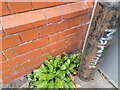
1
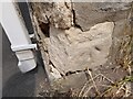
Ordnance Survey Cut Mark
This OS cut mark can be found on No22 Pleasant Road. It marks a point 80.022m above mean sea level.
Image: © Adrian Dust
Taken: 28 Jul 2022
0.08 miles
2
Staple Hill, nursery
Mama Bear's Day Nursery, on Downend Road.
Image: © Mike Faherty
Taken: 22 Jul 2011
0.13 miles
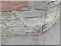
3
Ordnance Survey Cut Mark
This OS cut mark can be found on the wall of No32 Victoria Street. It marks a point 83.927m above mean sea level.
Image: © Adrian Dust
Taken: 28 Jul 2022
0.14 miles
4
Ordnance Survey Cut Mark
This OS cut mark can be found on the NE angle of Christ Church. It marks a point 75.048m above mean sea level.
Image: © Adrian Dust
Taken: 28 Jul 2022
0.14 miles
5
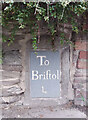
Old Milestone by the A432, Downend Road, Downend and Bromley Heath
Metal plate (replica) attached to stone post by the A432, in parish of Downend and Bromley Heath (SOUTH GLOUCESTERSHIRE District), Downend Road; opposite junction with Christchurch Lane, by No. 72B, built into wall, on North side of road, Eat of Diall Lane alley. Bristol incised iron plate, erected by the Bristol turnpike trust in the 18th century.
Inscription reads:-
To
Briftol
4
Milestone Society National ID: GL_BRSY04
Image: © Nick Gillett
Taken: 7 May 2023
0.16 miles
6

Old Milestone by the A432, Downend Road, Downend and Bromley Heath
Metal plate (replica) attached to stone post by the A432, in parish of Downend and Bromley Heath (SOUTH GLOUCESTERSHIRE District), Downend Road; opposite junction with Christchurch Lane, by No. 72B, built into wall, on North side of road, Eat of Diall Lane alley. Bristol incised iron plate, erected by the Bristol turnpike trust in the 18th century.
Inscription reads:-
To
Briftol
4
Milestone Society National ID: GL_BRSY04
Image: © M Faherty
Taken: 22 Jul 2011
0.16 miles
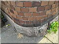
7
Ordnance Survey Cut Mark
This OS cut mark can be found on the Duck & Willow PH. It marks a point 72.488m above mean sea level.
Image: © Adrian Dust
Taken: 28 Jul 2022
0.17 miles
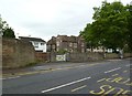
8
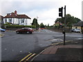
Crossroads at the top of Croome Hill
Part of a thatched single-story house can be seen on the right. Thatch is unusual in this area.
Image: © William Avery
Taken: 17 Sep 2006
0.18 miles
9

Staple Hill Methodist Church
The Hebron United Methodist Free Church was built in 1874.
Image: © Neil Owen
Taken: 24 Jan 2023
0.22 miles
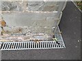
10
Ordnance Survey Cut Mark
This OS cut mark can be found on the wall of N0110 North Street. It marks a point 72.859m above mean sea level.
Image: © Adrian Dust
Taken: 28 Jul 2022
0.22 miles