IMAGES TAKEN NEAR TO
Heathcote Road, BRISTOL, BS16 5SS
Introduction
This page details the photographs taken nearby to Heathcote Road, BS16 5SS by members of the Geograph project.
The Geograph project started in 2005 with the aim of publishing, organising and preserving representative images for every square kilometre of Great Britain, Ireland and the Isle of Man.

There are currently over 7.5m images from over14,400 individuals and you can help contribute to the project by visiting https://www.geograph.org.uk
Image Map
Images are licensed for reuse under creativecommons.org/licenses/by-sa/2.0
Notes
- Clicking on the map will re-center to the selected point.
- The higher the marker number, the further away the image location is from the centre of the postcode.
Image Listing (27 Images Found)
Images are licensed for reuse under creativecommons.org/licenses/by-sa/2.0
Image
Details
Distance
1
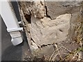
Ordnance Survey Cut Mark
This OS cut mark can be found on the wall of No32 Victoria Street. It marks a point 83.927m above mean sea level.
Image: © Adrian Dust
Taken: 28 Jul 2022
0.14 miles
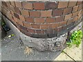
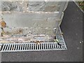
2
Ordnance Survey Cut Mark
This OS cut mark can be found on the wall west side of Park Road. It marks a point 79.510m above mean sea level.
Image: © Adrian Dust
Taken: 28 Jul 2022
0.14 miles
3
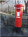
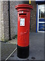
Letterbox on the corner of the park
Standing outside Page Park, at the junction of Park Road and South View, this George V letterbox has had a recent lick of paint. Looking closely, it was applied by with a brush. Another by Carron of Stirlingshire.
Image: © Neil Owen
Taken: 24 Jan 2023
0.16 miles
4
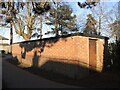
A war relic in a corner of the park
In WWII Page Park was selected for the construction of an air raid shelter in 1939. It is now used as a store. Records show that bombing was a rare experience in Staple Hill, but two children were killed in the big Bristol raid of November, 1940.
Image: © Neil Owen
Taken: 24 Jan 2023
0.16 miles
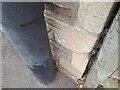
5
Ordnance Survey Cut Mark
This OS cut mark can be found on No22 Pleasant Road. It marks a point 80.022m above mean sea level.
Image: © Adrian Dust
Taken: 28 Jul 2022
0.16 miles
6
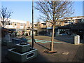
The Square, Staple Hill
A modern precinct for shoppers stands on what used to be a row of old houses in the fairly recent past.
Image: © Neil Owen
Taken: 24 Jan 2023
0.17 miles
7

Memorial to Firefighter Fleur Lombard QGM
Fleur was the first female firefighter to be killed in action in Britain since World War II. She was searching a burning Co-op supermarket (located across the road from the memorial, on the site where the local Tesco now stands) for "persons reported" when she was caught, and died instantly, in a flashover.
More about Fleur here http://en.wikipedia.org/wiki/Fleur_Lombard
See also Image
Image: © Roger Lombard
Taken: 29 May 2009
0.18 miles
8
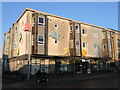
Staple Hill library
A post-war library, bearing some colourful 'pages'.
Image: © Neil Owen
Taken: 24 Jan 2023
0.18 miles
9
Broad Street box
A George V letterbox stands amongst the modern shops and houses on Broad Street. Cast by Carron.
Image: © Neil Owen
Taken: 24 Jan 2023
0.19 miles
10
Ordnance Survey Cut Mark
This OS cut mark can be found on the NE angle of Christ Church. It marks a point 75.048m above mean sea level.
Image: © Adrian Dust
Taken: 28 Jul 2022
0.19 miles