IMAGES TAKEN NEAR TO
Peache Road, BRISTOL, BS16 5RW
Introduction
This page details the photographs taken nearby to Peache Road, BS16 5RW by members of the Geograph project.
The Geograph project started in 2005 with the aim of publishing, organising and preserving representative images for every square kilometre of Great Britain, Ireland and the Isle of Man.

There are currently over 7.5m images from over14,400 individuals and you can help contribute to the project by visiting https://www.geograph.org.uk
Image Map
Images are licensed for reuse under creativecommons.org/licenses/by-sa/2.0
Notes
- Clicking on the map will re-center to the selected point.
- The higher the marker number, the further away the image location is from the centre of the postcode.
Image Listing (5 Images Found)
Images are licensed for reuse under creativecommons.org/licenses/by-sa/2.0
Image
Details
Distance
1
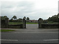
Mangotsfield, playing field
King George's Field, off Downend Road.
Image: © Mike Faherty
Taken: 29 Oct 2010
0.12 miles
2
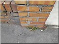
Ordnance Survey Cut Mark
This OS cut mark can be found on the wall between Nos 65/67 Salisbury Road. It marks a point 69.019m above mean sea level.
Image: © Adrian Dust
Taken: 28 Jul 2022
0.19 miles
3
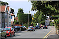
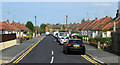
2011 : Buckingham Place, Downend, Bristol
Looking north toward Westerleigh Road.
Image: © Maurice Pullin
Taken: 2 Aug 2011
0.23 miles
4
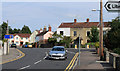
2011 : Salisbury Road, Downend, Bristol
Looking east.
Park Road heads off to the right to Page Park and Staple Hill.
The library is at the other end of Buckingham Gardens, a turning off Buckingham Place.
A mixture of old, new and middle aged houses.
Image: © Maurice Pullin
Taken: 2 Aug 2011
0.24 miles
5
2011 : Bungalows on Buckingham Gardens
Seen from Buckingham Place.
The library is at the far end of this cul-de-sac.
Image: © Maurice Pullin
Taken: 2 Aug 2011
0.25 miles