IMAGES TAKEN NEAR TO
The Hawthornes, BRISTOL, BS16 5PB
Introduction
This page details the photographs taken nearby to The Hawthornes, BS16 5PB by members of the Geograph project.
The Geograph project started in 2005 with the aim of publishing, organising and preserving representative images for every square kilometre of Great Britain, Ireland and the Isle of Man.

There are currently over 7.5m images from over14,400 individuals and you can help contribute to the project by visiting https://www.geograph.org.uk
Image Map
Images are licensed for reuse under creativecommons.org/licenses/by-sa/2.0
Notes
- Clicking on the map will re-center to the selected point.
- The higher the marker number, the further away the image location is from the centre of the postcode.
Image Listing (46 Images Found)
Images are licensed for reuse under creativecommons.org/licenses/by-sa/2.0
Image
Details
Distance
1
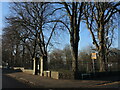
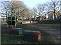
Corner of Page Park
The park at the junction of Broad Street and Hill House Road, with a benchmark at the gates. See Image In the past the area was part of the Hill House estate before urbanisation encroached as coal mining brought more settlement. The manor house is no longer present but the owner created the park we have today.
Image: © Neil Owen
Taken: 24 Jan 2023
0.08 miles
2
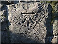
Page Park benchmark
A cutmark, as listed in the Benchmark Database: https://www.bench-marks.org.uk/bm80220 , on the south-east entrance gates to Page Park. See Image] for a wider view.
Image: © Neil Owen
Taken: 24 Jan 2023
0.08 miles
3
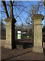
Page Park gates
The south-east entrance and its ironwork.
Image: © Neil Owen
Taken: 24 Jan 2023
0.08 miles
4
Teen play area in Page Park
Some modern equipment for modern youngsters.
Image: © Neil Owen
Taken: 24 Jan 2023
0.09 miles
5
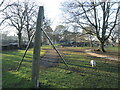
Bigger kit for bigger kids
A Teen Play Area is perhaps the most modern installation in Page Park.
Image: © Neil Owen
Taken: 24 Jan 2023
0.11 miles
6
Page Park tennis courts
Tennis courts were provided by Page Institute Ladies Committee in 1929, and the pavilion built a year after. Today they are hard courts but the originals were grass.
Image: © Neil Owen
Taken: 24 Jan 2023
0.12 miles
7
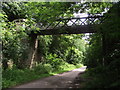
Charnhill Footbridge
Charnhill footbridge crosses the former Bristol and Gloucester railway, now a cycle path.
Image: © Andy Stone
Taken: 25 Jun 2012
0.12 miles
8
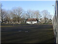
Burley Grove
Road junction where Burley Grove joins Mangotsfield Road, looking west. The small road which borders the grassy area is Broad St.
Image: © Linda Bailey
Taken: 24 May 2006
0.13 miles
9
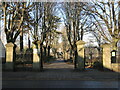
Main entrance gates to Page Park
The area around Staple Hill was once an estate belonging to Hill House, a grand pile that stood where Haycroft Court is now. Arthur William Page owned it and was a local parliamentarian, solicitor, a Justice of the Peace and was elected Alderman of the county of Gloucestershire in 1910. In that year he donated nineteen acres of his land to the parish which formed that basis of the new park.
In 1931 memorial gates were hung at this entrance. Beyond down the path is the central clock tower.
Image: © Neil Owen
Taken: 24 Jan 2023
0.13 miles
10
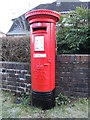
Letterbox on Mangotsfield Road
A George V version by Carron. Looking smart thanks to a recent hand-painting.
Image: © Neil Owen
Taken: 24 Jan 2023
0.14 miles