IMAGES TAKEN NEAR TO
Park Road, BRISTOL, BS16 5LF
Introduction
This page details the photographs taken nearby to Park Road, BS16 5LF by members of the Geograph project.
The Geograph project started in 2005 with the aim of publishing, organising and preserving representative images for every square kilometre of Great Britain, Ireland and the Isle of Man.

There are currently over 7.5m images from over14,400 individuals and you can help contribute to the project by visiting https://www.geograph.org.uk
Image Map
Images are licensed for reuse under creativecommons.org/licenses/by-sa/2.0
Notes
- Clicking on the map will re-center to the selected point.
- The higher the marker number, the further away the image location is from the centre of the postcode.
Image Listing (46 Images Found)
Images are licensed for reuse under creativecommons.org/licenses/by-sa/2.0
Image
Details
Distance
1
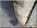
Ordnance Survey Cut Mark
This OS cut mark can be found on the wall west side of Park Road. It marks a point 79.510m above mean sea level.
Image: © Adrian Dust
Taken: 28 Jul 2022
0.02 miles
2
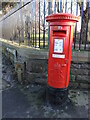
Letterbox on the corner of the park
Standing outside Page Park, at the junction of Park Road and South View, this George V letterbox has had a recent lick of paint. Looking closely, it was applied by with a brush. Another by Carron of Stirlingshire.
Image: © Neil Owen
Taken: 24 Jan 2023
0.04 miles
3
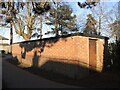
A war relic in a corner of the park
In WWII Page Park was selected for the construction of an air raid shelter in 1939. It is now used as a store. Records show that bombing was a rare experience in Staple Hill, but two children were killed in the big Bristol raid of November, 1940.
Image: © Neil Owen
Taken: 24 Jan 2023
0.06 miles
4
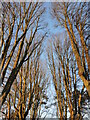
Bare trees in Page Park
Late afternoon sun in January gives the bare branches a golden shimmer.
Image: © Neil Owen
Taken: 24 Jan 2023
0.12 miles
5
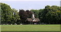
2011 : Clock Tower Page Park, Staple Hill, Bristol
A popular place for visitors to enjoy a little relaxation.
"Page Park is an early-20th-century public park laid out to a formal design and bordered by evenly spaced trees. There is a clock tower shelter at the centre of the park, flowerbeds, a bowling green and a tennis court.
The park was formerly part of the Hill House estate. It was given to the public in 1909 by A.W. Page and laid out over the next few years."
The above was copied from: http://www.parksandgardens.ac.uk/component/option,com_parksandgardens/task,site/id,2544/Itemid,292/
Image: © Maurice Pullin
Taken: 2 Aug 2011
0.15 miles
6
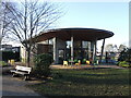
The Bean Tree Caf
Built with the aid of Lottery funding allowance, the Bean Tree Café was opened on Saturday 5th August, 2017. It features internal and external spaces, available for hire.
Image: © Neil Owen
Taken: 24 Jan 2023
0.15 miles
7
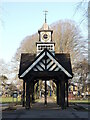
Page Park Clock Tower
The main feature, with a peal of four bells and restored in 2016-18.
Image: © Neil Owen
Taken: 24 Jan 2023
0.16 miles
8
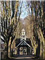
Clock tower avenue
Page Park's central jewel is the clock tower, with the path lined with trees.
Image: © Neil Owen
Taken: 24 Jan 2023
0.16 miles
9
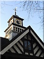
Time all around the park
The park and the clock tower were opened in 1910. Four clock faces surround the top and a peal of bells lie just below. In recent years the park received lots of money from various funds and set about improving the facilities and creating new attractions.
Image: © Neil Owen
Taken: 24 Jan 2023
0.16 miles
10
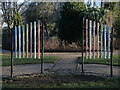
Tubular chimes
There was a small water feature here but supply problems and changes in regulations brought about its demolition; however, the chimes survive.
Image: © Neil Owen
Taken: 24 Jan 2023
0.16 miles