IMAGES TAKEN NEAR TO
Ducie Road, BRISTOL, BS16 5JZ
Introduction
This page details the photographs taken nearby to Ducie Road, BS16 5JZ by members of the Geograph project.
The Geograph project started in 2005 with the aim of publishing, organising and preserving representative images for every square kilometre of Great Britain, Ireland and the Isle of Man.

There are currently over 7.5m images from over14,400 individuals and you can help contribute to the project by visiting https://www.geograph.org.uk
Image Map
Images are licensed for reuse under creativecommons.org/licenses/by-sa/2.0
Notes
- Clicking on the map will re-center to the selected point.
- The higher the marker number, the further away the image location is from the centre of the postcode.
Image Listing (54 Images Found)
Images are licensed for reuse under creativecommons.org/licenses/by-sa/2.0
Image
Details
Distance
1
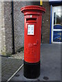
Broad Street box
A George V letterbox stands amongst the modern shops and houses on Broad Street. Cast by Carron.
Image: © Neil Owen
Taken: 24 Jan 2023
0.09 miles
2

Memorial to Firefighter Fleur Lombard QGM
Fleur was the first female firefighter to be killed in action in Britain since World War II. She was searching a burning Co-op supermarket (located across the road from the memorial, on the site where the local Tesco now stands) for "persons reported" when she was caught, and died instantly, in a flashover.
More about Fleur here http://en.wikipedia.org/wiki/Fleur_Lombard
See also Image
Image: © Roger Lombard
Taken: 29 May 2009
0.09 miles
3
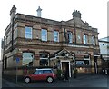
Billy Four
The pub on Broad Street, Staple Hill, dates back to the early 1900s.
Image: © Neil Owen
Taken: 24 Jan 2023
0.10 miles
4
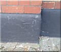
Ordnance Survey Cut Mark
This OS cut mark can be found on The King William IV PH. It marks a point 87.337m above mean sea level.
Image: © Adrian Dust
Taken: 19 Jul 2021
0.10 miles
5
Staple Hill library
A post-war library, bearing some colourful 'pages'.
Image: © Neil Owen
Taken: 24 Jan 2023
0.10 miles
6

A place for boxes
A parcel distribution locker stands outside Tesco's in downtown Staple Hill - one of a growing number of public access units.
Image: © Neil Owen
Taken: 24 Jan 2023
0.10 miles
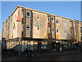
7
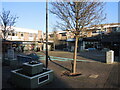
The Square, Staple Hill
A modern precinct for shoppers stands on what used to be a row of old houses in the fairly recent past.
Image: © Neil Owen
Taken: 24 Jan 2023
0.10 miles
8

The Forge and Fern
For many years since before the turn of the 1900s, this pub on the main road was the Red Lion. It closed a couple of years ago and has then found a new build has occupied the former car park beside it. All the structure to the left is original, the green wall and glass panelling are very much the new stuff.
Image: © Neil Owen
Taken: 24 Jan 2023
0.11 miles
9
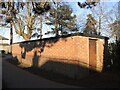
A war relic in a corner of the park
In WWII Page Park was selected for the construction of an air raid shelter in 1939. It is now used as a store. Records show that bombing was a rare experience in Staple Hill, but two children were killed in the big Bristol raid of November, 1940.
Image: © Neil Owen
Taken: 24 Jan 2023
0.12 miles
10
Older sign on Broad Street
Apart from the modern shop sign, there is also a small tablet set in the upper wall hinting of an older time. It must have been considered important enough to have its own moulding - there are no others on this row.
Image: © Neil Owen
Taken: 24 Jan 2023
0.12 miles