IMAGES TAKEN NEAR TO
James Road, BRISTOL, BS16 4SZ
Introduction
This page details the photographs taken nearby to James Road, BS16 4SZ by members of the Geograph project.
The Geograph project started in 2005 with the aim of publishing, organising and preserving representative images for every square kilometre of Great Britain, Ireland and the Isle of Man.

There are currently over 7.5m images from over14,400 individuals and you can help contribute to the project by visiting https://www.geograph.org.uk
Image Map (6 Images)


Getting Data...Please wait
Leaflet Map data © OpenStreetMap
Images are licensed for reuse under creativecommons.org/licenses/by-sa/2.0
Notes
- Clicking on the map will re-center to the selected point.
- The higher the marker number, the further away the image location is from the centre of the postcode.
Image Listing (6 Images Found)
Images are licensed for reuse under creativecommons.org/licenses/by-sa/2.0
Image
Details
Distance
1
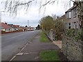
Gladstone Street, Soundwell
Seen from the point where a footpath runs off to the right towards Church Road alongside the playing field at the rear of Image
Image: © Derek Harper
Taken: 26 Mar 2010
0.12 miles
2
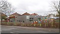
Nursery, Soundwell
Mama Bear’s Soundwell Day Nursery is in purpose-built premises, formerly part of Soundwell College, on Church Road.
Image: © Derek Harper
Taken: 26 Mar 2010
0.20 miles
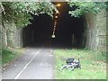
4
Eastern entrance to Staple Hill Tunnel, Bristol
From the Bristol-Bath cycle path. The tunnel remains open daily until dusk. Happily, trains no longer run to interfere with walkers and cyclists but constant lighting is needed to make the tunnel safe to navigate.
Image: © Anthony O'Neil
Taken: 12 May 2009
0.22 miles
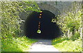
5
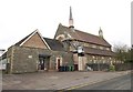
St Stephen's Church, Soundwell
The church, dating from about 1880, occupies the very southwest corner of the square, and the bellcote end of the building is in Image To the left is the church hall.
Image: © Derek Harper
Taken: 26 Mar 2010
0.23 miles
6
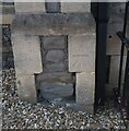
Ordnance Survey Cut Mark
This OS cut mark can be found on the NE angle of the Chapel on Soundwell Road. It marks a point 85.137m above mean sea level.
Image: © Adrian Dust
Taken: 19 Jul 2021
0.23 miles