IMAGES TAKEN NEAR TO
Alexandra Place, BRISTOL, BS16 4QL
Introduction
This page details the photographs taken nearby to Alexandra Place, BS16 4QL by members of the Geograph project.
The Geograph project started in 2005 with the aim of publishing, organising and preserving representative images for every square kilometre of Great Britain, Ireland and the Isle of Man.

There are currently over 7.5m images from over14,400 individuals and you can help contribute to the project by visiting https://www.geograph.org.uk
Image Map
Images are licensed for reuse under creativecommons.org/licenses/by-sa/2.0
Notes
- Clicking on the map will re-center to the selected point.
- The higher the marker number, the further away the image location is from the centre of the postcode.
Image Listing (27 Images Found)
Images are licensed for reuse under creativecommons.org/licenses/by-sa/2.0
Image
Details
Distance
1
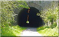
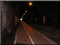
Eastern entrance to Staple Hill Tunnel, Bristol
From the Bristol-Bath cycle path. The tunnel remains open daily until dusk. Happily, trains no longer run to interfere with walkers and cyclists but constant lighting is needed to make the tunnel safe to navigate.
Image: © Anthony O'Neil
Taken: 12 May 2009
0.05 miles
3
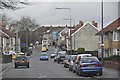
Bristol : Soundwell Road
Near Staple Hill and Kingswood in Bristol.
Image: © Lewis Clarke
Taken: 1 Feb 2013
0.08 miles
4
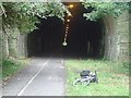
Inside Staple Hill Tunnel
I seem to recall that the lights are not on all the time, only during daylight hours when cyclists are using the Bristol & Bath Railway Track.
Image: © Ken Walton
Taken: 10 May 2005
0.09 miles
5
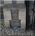
Ordnance Survey Cut Mark
This OS cut mark can be found on the NE angle of the Chapel on Soundwell Road. It marks a point 85.137m above mean sea level.
Image: © Adrian Dust
Taken: 19 Jul 2021
0.11 miles
6
Soundwell Road at the junction of Broad Street
Image: © David Howard
Taken: 1 Jun 2019
0.14 miles
7
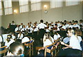
Staple Hill Citadel Songsters
The Songsters (choir) of the Staple Hill Salvation Army in action. Taken inside the Salvation Army hall in Broad Street.
Image: © Rob K Brettle
Taken: 25 Jun 2000
0.14 miles
8
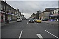
Bristol : High Street
The High Street in the Staple Hill area of Bristol in South Gloucestershire.
Image: © Lewis Clarke
Taken: 1 Feb 2013
0.15 miles
9
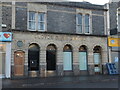
Banking on a good return
An old Lloyds branch closed about two years ago. Just recently, council approval has been given to convert it into a bookmaker's shop - much to the dismay of locals, who think they have enough already.
Whilst the branch had many changes of frontage in its time, the original gold stonework was finally revealed when the boards came down.
Image: © Neil Owen
Taken: 24 Jan 2023
0.15 miles
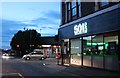
10
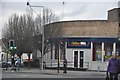
Bristol : William Hill Betting Shop
A betting shop on the junction between Victoria and Broad Street in Staple Hill.
Image: © Lewis Clarke
Taken: 1 Feb 2013
0.15 miles