IMAGES TAKEN NEAR TO
Frampton Crescent, BRISTOL, BS16 4JA
Introduction
This page details the photographs taken nearby to Frampton Crescent, BS16 4JA by members of the Geograph project.
The Geograph project started in 2005 with the aim of publishing, organising and preserving representative images for every square kilometre of Great Britain, Ireland and the Isle of Man.

There are currently over 7.5m images from over14,400 individuals and you can help contribute to the project by visiting https://www.geograph.org.uk
Image Map (15 Images)


Getting Data...Please wait
Leaflet Map data © OpenStreetMap
Images are licensed for reuse under creativecommons.org/licenses/by-sa/2.0
Notes
- Clicking on the map will re-center to the selected point.
- The higher the marker number, the further away the image location is from the centre of the postcode.
Image Listing (15 Images Found)
Images are licensed for reuse under creativecommons.org/licenses/by-sa/2.0
Image
Details
Distance
1
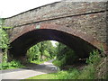
Thicket Avenue Bridge
Thicket Avenue crosses the former Bristol and Gloucester railway, now a cycle path.
Image: © Andy Stone
Taken: 25 Jun 2012
0.06 miles
2
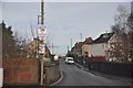
Bristol : Thicket Avenue
Thicket Avenue heading over the old railway and onto Thicket Road.
Image: © Lewis Clarke
Taken: 1 Feb 2013
0.06 miles
3
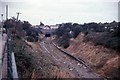
Staple Hill railway station (site), Bristol
Opened in 1888 by the Midland Railway on the line from Bristol to Mangotsfield, this station closed in 1966.
View west towards Bristol Temple Meads, also Clifton Down and Bristol St Philips. The former Bristol-bound platform to the left has become buried.
Image: © Nigel Thompson
Taken: 31 Mar 2018
0.09 miles
4
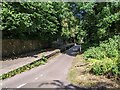
Old railway station now on the Bristol and Bath cycleway
Image: © Rob Purvis
Taken: 29 Jun 2023
0.11 miles
5
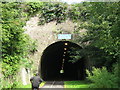
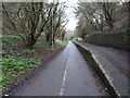
Staple Hill tunnel - west portal
on the Bristol-Bath railway path
Image: © Peter Goodwin
Taken: 18 Aug 2006
0.14 miles
7
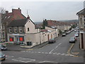
Looking down Cassell Road, Staple Hill
This photo was taken from the first floor bedroom of my parents house in staple Hill. I've always loved the view from here and wanted a photo to keep as they've recently moved out.
Image: © Alice Hall
Taken: 19 Feb 2007
0.18 miles
8
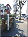
Old Bristol in newer Bristol
A rare old city and county boundary post on the junction of Staplehill Road and Thicket Road. The boundary was actually a short distance to the east of the post, though is now much further today. See Image] for a context view.
Incidentally, Bristol was made a city and county in its own right by a charter by Edward III in 1373.
Image: © Neil Owen
Taken: 3 Apr 2023
0.21 miles
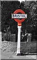
9
You are now in the city of Bristol
An old boundary post on Staplehill Road marks the extent of the old city. See Image] for a closer look at this uncommon but out-dated sign.
Image: © Neil Owen
Taken: 3 Apr 2023
0.21 miles
10
Old Boundary Marker on the B4465 High Street, Staple Hill, Bristol
County Boundary Marker by the B4465, in parish of Bristol (City Of Bristol District), against a brick wall in Staple Hill on the southwest side of the junction of the B4465 High Street and Thicket Road. Listing details https://historicengland.org.uk/listing/the-list/list-entry/1418104.
To be surveyed (Grade II Listed)
Milestone Society National ID: GL_BRIS03cb
Image: © S Kosciow
Taken: 8 May 2018
0.21 miles