IMAGES TAKEN NEAR TO
The Greenway, BRISTOL, BS16 4HT
Introduction
This page details the photographs taken nearby to The Greenway, BS16 4HT by members of the Geograph project.
The Geograph project started in 2005 with the aim of publishing, organising and preserving representative images for every square kilometre of Great Britain, Ireland and the Isle of Man.

There are currently over 7.5m images from over14,400 individuals and you can help contribute to the project by visiting https://www.geograph.org.uk
Image Map (Loading...)


Getting Data...Please wait
Leaflet Map data © OpenStreetMap
Images are licensed for reuse under creativecommons.org/licenses/by-sa/2.0
Notes
- Clicking on the map will re-center to the selected point.
- The higher the marker number, the further away the image location is from the centre of the postcode.
Image Listing (2 Images Found)
Images are licensed for reuse under creativecommons.org/licenses/by-sa/2.0
Image
Details
Distance
1
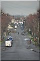
Bristol : Thicket Avenue
Thicket Avenue heading through residential areas towards Stapleton Road.
Image: © Lewis Clarke
Taken: 1 Feb 2013
0.13 miles
2
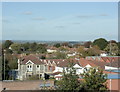
2009 : North from the top of Lodge Hill
The stone built house left foreground was almost certainly made of local stone from quarries in Fishponds.
The houses beyond are part of the Hillfields Park estate built during the 1920/30's by the local council.
In the distance we look over South Gloucestershire in the area of Winterbourne and Coalpit Heath.
Image: © Maurice Pullin
Taken: 12 Oct 2009
0.22 miles