IMAGES TAKEN NEAR TO
Maywood Road, BRISTOL, BS16 4AR
Introduction
This page details the photographs taken nearby to Maywood Road, BS16 4AR by members of the Geograph project.
The Geograph project started in 2005 with the aim of publishing, organising and preserving representative images for every square kilometre of Great Britain, Ireland and the Isle of Man.

There are currently over 7.5m images from over14,400 individuals and you can help contribute to the project by visiting https://www.geograph.org.uk
Image Map (Loading...)


Getting Data...Please wait
Leaflet Map data © OpenStreetMap
Images are licensed for reuse under creativecommons.org/licenses/by-sa/2.0
Notes
- Clicking on the map will re-center to the selected point.
- The higher the marker number, the further away the image location is from the centre of the postcode.
Image Listing (18 Images Found)
Images are licensed for reuse under creativecommons.org/licenses/by-sa/2.0
Image
Details
Distance
1
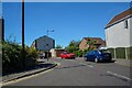
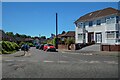
Bristol : Eaton Close
Looking off Forest Road.
Image: © Lewis Clarke
Taken: 10 Aug 2022
0.11 miles
2
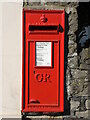
Letterbox on Staple Hill Road
A George V version set into the wall, by W. T. Allen.
Image: © Neil Owen
Taken: 3 Apr 2023
0.12 miles
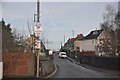
3
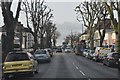
Bristol : Staplehill Road
Staplehill Road heading through the suburbs of Bristol.
Image: © Lewis Clarke
Taken: 1 Feb 2013
0.13 miles
4
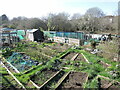
Marshfield Road allotments
A small but valued patch, the allotments used to be much larger and occupied both embankments of the railway line just beyond.
Image: © Neil Owen
Taken: 3 Apr 2023
0.14 miles
5
Bristol : Brook Road
Looking off Forest Road.
Image: © Lewis Clarke
Taken: 10 Aug 2022
0.16 miles
6
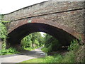
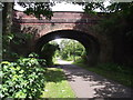
Thicket Avenue Bridge
Thicket Avenue crosses the former Bristol and Gloucester railway, now a cycle path.
Image: © Andy Stone
Taken: 25 Jun 2012
0.16 miles
7
Bristol : Thicket Avenue
Thicket Avenue heading over the old railway and onto Thicket Road.
Image: © Lewis Clarke
Taken: 1 Feb 2013
0.16 miles
8
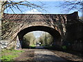
Forest Road bridge
The steam and soot are long since consigned to history. Today the speed is provided by cyclists.
Image: © Neil Owen
Taken: 3 Apr 2023
0.17 miles
9
Forest Road Bridge
Forest road crosses the former Bristol and Gloucester railway, now a cycle path.
Image: © Andy Stone
Taken: 25 Jun 2012
0.18 miles
10
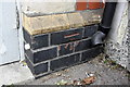
Benchmark on the Cross Hands pub, Staplehill Road face
Ordnance Survey cut mark benchmark described on the Bench Mark Database at http://www.bench-marks.org.uk/bm48029
Image: © Roger Templeman
Taken: 9 Apr 2013
0.18 miles