IMAGES TAKEN NEAR TO
Maywood Road, BRISTOL, BS16 4AL
Introduction
This page details the photographs taken nearby to Maywood Road, BS16 4AL by members of the Geograph project.
The Geograph project started in 2005 with the aim of publishing, organising and preserving representative images for every square kilometre of Great Britain, Ireland and the Isle of Man.

There are currently over 7.5m images from over14,400 individuals and you can help contribute to the project by visiting https://www.geograph.org.uk
Image Map
Images are licensed for reuse under creativecommons.org/licenses/by-sa/2.0
Notes
- Clicking on the map will re-center to the selected point.
- The higher the marker number, the further away the image location is from the centre of the postcode.
Image Listing (23 Images Found)
Images are licensed for reuse under creativecommons.org/licenses/by-sa/2.0
Image
Details
Distance
1
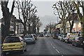
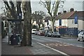
Bristol : Staplehill Road
Staplehill Road heading through the suburbs of Bristol.
Image: © Lewis Clarke
Taken: 1 Feb 2013
0.06 miles
2
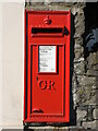
Letterbox on Staple Hill Road
A George V version set into the wall, by W. T. Allen.
Image: © Neil Owen
Taken: 3 Apr 2023
0.07 miles
3
Bristol : Stanbury Avenue
A small road between Staplehill Road and Downend Road.
Image: © Lewis Clarke
Taken: 1 Feb 2013
0.12 miles
4
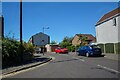
Bristol : Eaton Close
Looking off Forest Road.
Image: © Lewis Clarke
Taken: 10 Aug 2022
0.12 miles
5
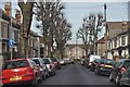
Bristol : Staplehill Road
Staplehill Road in Bristol with people waiting at the bus stop.
Image: © Lewis Clarke
Taken: 1 Feb 2013
0.16 miles
6
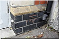
Benchmark on the Cross Hands pub, Staplehill Road face
Ordnance Survey cut mark benchmark described on the Bench Mark Database at http://www.bench-marks.org.uk/bm48029
Image: © Roger Templeman
Taken: 9 Apr 2013
0.16 miles
7
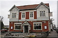
Cross Hands public house
The pub is at the junction of Staplehill Road (right of the pub) and Downend Road (left of the pub). There is an OS benchmark Image on the Staplehill Road face under the 'BICYCLES' sign.
Image: © Roger Templeman
Taken: 9 Apr 2013
0.17 miles
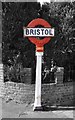
8
Old Bristol in newer Bristol
A rare old city and county boundary post on the junction of Staplehill Road and Thicket Road. The boundary was actually a short distance to the east of the post, though is now much further today. See Image] for a context view.
Incidentally, Bristol was made a city and county in its own right by a charter by Edward III in 1373.
Image: © Neil Owen
Taken: 3 Apr 2023
0.17 miles
9
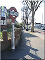
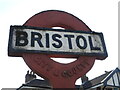
You are now in the city of Bristol
An old boundary post on Staplehill Road marks the extent of the old city. See Image] for a closer look at this uncommon but out-dated sign.
Image: © Neil Owen
Taken: 3 Apr 2023
0.17 miles
10
Old Boundary Marker on the B4465 High Street, Staple Hill, Bristol
County Boundary Marker by the B4465, in parish of Bristol (City Of Bristol District), against a brick wall in Staple Hill on the southwest side of the junction of the B4465 High Street and Thicket Road. Listing details https://historicengland.org.uk/listing/the-list/list-entry/1418104.
To be surveyed (Grade II Listed)
Milestone Society National ID: GL_BRIS03cb
Image: © S Kosciow
Taken: 8 May 2018
0.17 miles