IMAGES TAKEN NEAR TO
Fishponds Road, BRISTOL, BS16 3TE
Introduction
This page details the photographs taken nearby to Fishponds Road, BS16 3TE by members of the Geograph project.
The Geograph project started in 2005 with the aim of publishing, organising and preserving representative images for every square kilometre of Great Britain, Ireland and the Isle of Man.

There are currently over 7.5m images from over14,400 individuals and you can help contribute to the project by visiting https://www.geograph.org.uk
Image Map
Images are licensed for reuse under creativecommons.org/licenses/by-sa/2.0
Notes
- Clicking on the map will re-center to the selected point.
- The higher the marker number, the further away the image location is from the centre of the postcode.
Image Listing (56 Images Found)
Images are licensed for reuse under creativecommons.org/licenses/by-sa/2.0
Image
Details
Distance
1
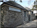
Toilet block in Fishponds Park
The park opened in 1888, without provision initially. A small urinal was built in the early twentieth century and these blocks replaced it later.
Image: © Neil Owen
Taken: 3 Apr 2023
0.03 miles
2
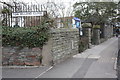
Milestone, park entrance and public conveniences, Fishponds Road
There is a detailed view of the 'Bristol 3' milestone and its OS benchmark at Image
Image: © Roger Templeman
Taken: 9 Apr 2013
0.03 miles
3
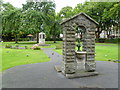
Fishponds, fountain
In Fishponds Park; presented by John Yalland in 1893 to commemorate the opening of the park. In the background, WWI war memorial.
Image: © Mike Faherty
Taken: 22 Jul 2011
0.03 miles
4
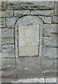
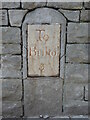
Old Milestone by the A432, Fishponds Road, Bristol parish
Metal plate attached to stone post by the A432, in parish of Bristol (City of Bristol District), Fishponds Road, East side of park wall, opposite junction with Beechwood Road at Fishponds Park, on West side of road. Bristol incised iron plate, erected by the Bristol turnpike trust in the 19th century.
Inscription reads:-
To
Briftol
3
Milestone Society National ID: GL_BRSY03
Image: © M Faherty
Taken: 6 Mar 2015
0.04 miles
5

Restaurant entrance with a large clock
The post-war building on Fishponds Road is presently a restaurant, with a large clock above it in period style.
Image: © Neil Owen
Taken: 3 Apr 2023
0.04 miles
6
Three miles to old Bristol
In the past Bristol's boundaries were much further down the Fishponds Road, notwithstanding that the milestone is now inside the city line. Also on the stone is a faint benchmark; see Image] for a wider view and https://www.bench-marks.org.uk/bm48021 for the entry in the Benchmark Database.
Image: © Neil Owen
Taken: 3 Apr 2023
0.04 miles
7
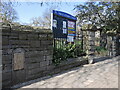
Entrance to the park and church
St Mary's church has been part of the parish of Fishponds for many centuries and is accessible from the main road. In the nineteenth century, the small public park was established in the grounds before the church.
Retained in the wall is an old milestone, denoting it is 3 miles to Bristol (note that in the past Bristol's boundary was further southwest of here). See Image] for a look at the benchmark on the milestone.
Image: © Neil Owen
Taken: 3 Apr 2023
0.04 miles
8
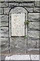
Old milestone in wall of Fishponds Road
The milestone indicates 3 miles to Bristol, and has a weathered Ordnance Survey cut mark benchmark below the mileage plate. The stone and benchmark are over 100 years old, both shown on the 1882 map. The mark is described on the Bench Mark Database at http://www.bench-marks.org.uk/bm48021
Image: © Roger Templeman
Taken: 9 Apr 2013
0.04 miles
9
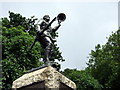
War memorial in Fishponds Park
This rather striking memorial is for the local men who fell in the Great War. The figure is mounted on a granite plinth with plaques listing the dead on all sides.
This memorial was one of many memorials designed and executed by the company Humphrys and Oakes- ecclesiastical craftsmen- of 109 Lawrence Hill, Bristol.
[Information supplied by Mary Gunningham, grandaughter of Charles Frederick Oakes.]
Image: © Natasha Ceridwen de Chroustchoff
Taken: 15 Jul 2008
0.04 miles
10

In Fishponds Park
Victorian pleasure grounds
Image: © Anthony O'Neil
Taken: 22 Jan 2021
0.05 miles