IMAGES TAKEN NEAR TO
Chester Park Road, BRISTOL, BS16 3RG
Introduction
This page details the photographs taken nearby to Chester Park Road, BS16 3RG by members of the Geograph project.
The Geograph project started in 2005 with the aim of publishing, organising and preserving representative images for every square kilometre of Great Britain, Ireland and the Isle of Man.

There are currently over 7.5m images from over14,400 individuals and you can help contribute to the project by visiting https://www.geograph.org.uk
Image Map
Images are licensed for reuse under creativecommons.org/licenses/by-sa/2.0
Notes
- Clicking on the map will re-center to the selected point.
- The higher the marker number, the further away the image location is from the centre of the postcode.
Image Listing (12 Images Found)
Images are licensed for reuse under creativecommons.org/licenses/by-sa/2.0
Image
Details
Distance
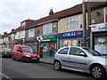
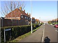
2
Berkeley Rd
Berkeley Rd is a short residential street with a mixed collection of mainly small terraced housing.
Image: © Nigel Mykura
Taken: 23 Feb 2013
0.10 miles
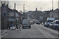
3
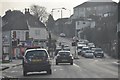
Bristol : Lodge Causeway B4048
Heading towards the junction with Tricket Avenue on Lodge Causeway.
Image: © Lewis Clarke
Taken: 1 Feb 2013
0.13 miles
4
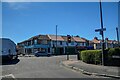
Bristol : Forest Road
Looking towards the road junction with Lodge Causeway.
Image: © Lewis Clarke
Taken: 10 Aug 2022
0.13 miles
5
Bristol : Lodge Causeway B4048
Lodge Causeway near Stapleton in Bristol.
Image: © Lewis Clarke
Taken: 1 Feb 2013
0.17 miles
7
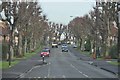
Bristol : Thicket Avenue
Thicket Avenue between Lodge Causeway and Staplehill Road.
Image: © Lewis Clarke
Taken: 1 Feb 2013
0.19 miles
8
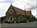
Fishponds, Bristol, St Joseph's Catholic Church
http://www.churchcrawler.pwp.blueyonder.co.uk/bristol2/fishjose.htm
Image: © ChurchCrawler
Taken: Unknown
0.19 miles
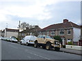
9
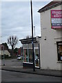
Kev's Barber Shop
On the corner of Lodge Hill and Woodlands Way, Kingswood.
Image: © Eirian Evans
Taken: 16 Feb 2011
0.19 miles
10
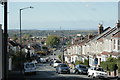
2009 : B4048 Lodge Hill, Chester Park, Bristol
Seen from near the top of the hill with Lodge Causeway at the bottom running to Fishponds.
The stone built houses on the right pre-date the housing estate, mistly brick, which was built in the 1920/30's.
The most obvious item further over is the Post Office Tower standing on Pur Down Image
The distant hills, faint on the horizon, are on the other side of the Bristol Channel.
"Lodge Causeway is an ancient passage through the former Royal Forest of Kingswood and now the main road between Fishponds and Kingswood in Bristol, England.
The Causeway led to Kingswood Lodge at the top of Lodge Hill, recorded in use since Saxon times when kings used the forest for hunting whilst resident at the palace at Pucklechurch, where King Edmund was murdered by an outlaw in 946. It passes through the Fishponds suburbs of Hillfields, Mayfield Park and Chester Park."
The above was copied from: http://en.wikipedia.org/wiki/Lodge_Causeway
Image: © Maurice Pullin
Taken: 12 Oct 2009
0.24 miles