IMAGES TAKEN NEAR TO
Lodge Causeway, BRISTOL, BS16 3JA
Introduction
This page details the photographs taken nearby to Lodge Causeway, BS16 3JA by members of the Geograph project.
The Geograph project started in 2005 with the aim of publishing, organising and preserving representative images for every square kilometre of Great Britain, Ireland and the Isle of Man.

There are currently over 7.5m images from over14,400 individuals and you can help contribute to the project by visiting https://www.geograph.org.uk
Image Map
Images are licensed for reuse under creativecommons.org/licenses/by-sa/2.0
Notes
- Clicking on the map will re-center to the selected point.
- The higher the marker number, the further away the image location is from the centre of the postcode.
Image Listing (34 Images Found)
Images are licensed for reuse under creativecommons.org/licenses/by-sa/2.0
Image
Details
Distance
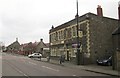
1
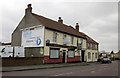
The Greyhound, Lodge Causeway
The pub lease is for sale. Its chances of survival are probably limited by the proximity of The Spotted Cow, only about 100 metres away.
Image: © Derek Harper
Taken: 31 Mar 2012
0.06 miles
2
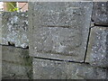
Benchmark on Lodge Causeway bridge
A cutmark, as listed in the Benchmark Database: https://www.bench-marks.org.uk/bm75899 , on the railway bridge. See Image] for a wider view of the bridge over what was the Bristol and Birmingham branch of the Midland Railway.
Image: © Neil Owen
Taken: 3 Apr 2023
0.07 miles
3
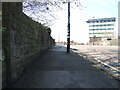
Lodge Causeway bridge
Once carrying the road over the old railway lines, the bridge remains a busy route, but for motors. A benchmark can be found on the near pier - see Image
Image: © Neil Owen
Taken: 3 Apr 2023
0.07 miles
4
Lodge House
Very ugly building on Fishponds Road
Image: © David Lally
Taken: 26 Jul 2011
0.13 miles
5
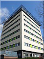
Beacon Tower
A modern block of flats, renovated in 2016.
Image: © Neil Owen
Taken: 3 Apr 2023
0.13 miles
6
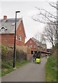
Bristol & Bath Railway Path at Ridgeway
Showing the well-used nature of the path.
These new houses have been neatly wedged into a small slot between Ernestville Road and the cyclepath; a path leaves the route between them. Just beyond them is the bridge carrying Lodge Causeway, the B4048.
Image: © Derek Harper
Taken: 31 Mar 2012
0.14 miles
7
The Spotted Cow, Lodge Causeway
Just 100 yards up the road (the B4048) from Image The car is about to turn out of Ridgeway Road. Beyond are Chester Park Junior and Infant Schools, followed by St John's Church.
Image: © Derek Harper
Taken: 31 Mar 2012
0.14 miles
8
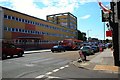
Bristol : Fishponds Road A432
Fishponds Road at the junction with Lodge Causeway with Beacon Tower in view.
Image: © Lewis Clarke
Taken: 1 Feb 2013
0.14 miles
9
Houses in Ridgeway Rd
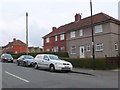
Ridgeway is a long bending residential road that climbs from its junction with Fishponds Rd the A432 in Upper Eastville to its junction with the B4048 Lodge Causeway at the western edge of Ridgeway district. This area has large numbers of red brick terraced and semidetached houses.
Image: © Nigel Mykura
Taken: 23 Feb 2013
0.14 miles
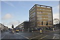
10
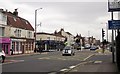
Fishponds Road at Ridgeway
The traffic lights at tunction of the A432 with Lodge Causeway, the B4048 (right). The left turn by the barbers (blue) is Grove Road.
Image: © Derek Harper
Taken: 31 Mar 2012
0.15 miles