IMAGES TAKEN NEAR TO
Alcove Road, BRISTOL, BS16 3AG
Introduction
This page details the photographs taken nearby to Alcove Road, BS16 3AG by members of the Geograph project.
The Geograph project started in 2005 with the aim of publishing, organising and preserving representative images for every square kilometre of Great Britain, Ireland and the Isle of Man.

There are currently over 7.5m images from over14,400 individuals and you can help contribute to the project by visiting https://www.geograph.org.uk
Image Map (Loading...)


Getting Data...Please wait
Leaflet Map data © OpenStreetMap
Images are licensed for reuse under creativecommons.org/licenses/by-sa/2.0
Notes
- Clicking on the map will re-center to the selected point.
- The higher the marker number, the further away the image location is from the centre of the postcode.
Image Listing (16 Images Found)
Images are licensed for reuse under creativecommons.org/licenses/by-sa/2.0
Image
Details
Distance
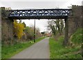
1
Bristol to Bath cycleway, on the old railway track
Image: © Rob Purvis
Taken: 24 Aug 2018
0.05 miles
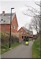
2
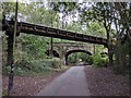
Bridges over the Bristol & Bath Railway Path
Ridgeway Road crosses the main bridge; the nearer footbridge saves pedestrians a dangerous corner on the road, where there is no footway.
Image: © Derek Harper
Taken: 31 Mar 2012
0.08 miles
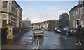
3
Fishponds Road, Ridgeway, looking WNW
In the part of Bristol called Ridgeway, on the A432 (Fishponds Road), looking WNW. The junction with the B4048 is next to the tall cream coloured building visible above the traffic island. The turning immediately on the right (at bottom of picture) is into Alcove Road at its western-most end.
Image: © Colin S Pearson
Taken: 23 Oct 2005
0.10 miles
4
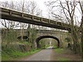
Footbridge, Ridgeway
Linking Drummond Road to Halstock Avenue across the Bristol & Bath Railway Path.
Image: © Derek Harper
Taken: 31 Mar 2012
0.11 miles
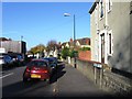
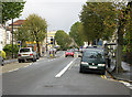
7
Bristol : Hawkesbury Road
Hawkesbury Road seen from the junction with Fishponds Road.
Image: © Lewis Clarke
Taken: 1 Feb 2013
0.15 miles
8
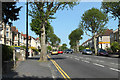
2011 : A432 Fishponds Road, Upper Eastville
Heading north east toward Fishponds and Downend. The corner shop with the yellow frontage is at the end of Ridgeway Road.
The trees are London planes, planted around 1900. They lose their bark in patches each year, at one time it was an annual event for concerned persons to write letters to the local papers complaining of "vandals stripping the bark and why do the police do nothing about it."
The following is from http://en.wikipedia.org/wiki/London_plane
"The London plane is very tolerant of atmospheric pollution and root compaction, and for this reason it is a popular urban roadside tree."
and
"The London Plane is a large deciduous tree growing to 20–35 m (exceptionally over 40 m) tall, with a trunk up to 3 m or more in circumference. The bark is usually pale grey-green, smooth and exfoliating, or buff-brown and not exfoliating. The leaves are thick and stiff-textured, broad, palmately lobed, superficially maple-like, the leaf blade 10–20 cm long and 12–25 cm broad, with a petiole 3–10 cm long. The young leaves in spring are coated with minute, fine, stiff hairs at first, but these wear off and by late summer the leaves are hairless or nearly so. The flowers are borne in one to three (most often two) dense spherical inflorescences on a pendulous stem, with male and female flowers on separate stems. The fruit matures in about 6 months, to 2–3 cm diameter, and comprises a dense spherical cluster of achenes with numerous stiff hairs which aid wind dispersal; the cluster breaks up slowly over the winter to release the numerous 2–3 mm seeds."
Image: © Maurice Pullin
Taken: 2 May 2011
0.16 miles
9
Bristol & Bath Railway Path at Ridgeway
Showing the well-used nature of the path.
These new houses have been neatly wedged into a small slot between Ernestville Road and the cyclepath; a path leaves the route between them. Just beyond them is the bridge carrying Lodge Causeway, the B4048.
Image: © Derek Harper
Taken: 31 Mar 2012
0.19 miles
