IMAGES TAKEN NEAR TO
Goffenton Drive, BRISTOL, BS16 2QA
Introduction
This page details the photographs taken nearby to Goffenton Drive, BS16 2QA by members of the Geograph project.
The Geograph project started in 2005 with the aim of publishing, organising and preserving representative images for every square kilometre of Great Britain, Ireland and the Isle of Man.

There are currently over 7.5m images from over14,400 individuals and you can help contribute to the project by visiting https://www.geograph.org.uk
Image Map
Images are licensed for reuse under creativecommons.org/licenses/by-sa/2.0
Notes
- Clicking on the map will re-center to the selected point.
- The higher the marker number, the further away the image location is from the centre of the postcode.
Image Listing (19 Images Found)
Images are licensed for reuse under creativecommons.org/licenses/by-sa/2.0
Image
Details
Distance
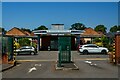
1
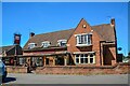
Bristol : The Oldbury Court Inn
A pub on Gill Avenue.
Image: © Lewis Clarke
Taken: 10 Aug 2022
0.12 miles
2
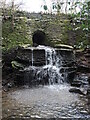
Tumbling to the Frome
A small tributary to the River Frome is crossed by a small stone footbridge, which allows it to cascade a little.
Image: © Neil Owen
Taken: 13 Apr 2023
0.13 miles
3
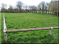
Overflow in Oldbury Court
A small car park for visitors has a second area set aside for particularly busy days.
Image: © Neil Owen
Taken: 13 Apr 2023
0.15 miles
4
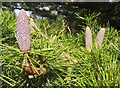
Cones, Oldbury Court
These are on a neighbour of Image], possibly another specimen of Cedrus deodara.
Image: © Derek Harper
Taken: 25 Sep 2014
0.15 miles
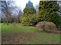
5
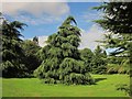
Tree, Oldbury Court
This looks rather like Cedrus deodara in the grounds of Oldbury Court.
Image: © Derek Harper
Taken: 25 Sep 2014
0.16 miles
6
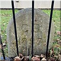
Old Boundary Marker on Gill Avenue, Bristol
Municipal Boundary Marker on the northwest side of Gill Avenue, Bristol, behind the front garden railings of No.155. Until 1897 the boundary of Stapleton and Mangotsfield parishes, until 1927 Bristol and Mangotsfield, until 1966 Bristol and Mangotsfield Urban, then entirely in Bristol.
Milestone Society National ID: GL_BRIS18pb
Image: © S Kosciow
Taken: 21 Sep 2021
0.16 miles
7
A holey tree
Not a religious site but one where a tree has a large opening. It still seems to be in decent health though.
Image: © Neil Owen
Taken: 13 Apr 2023
0.18 miles
8
2011 : Gill Avenue, Fishponds, Bristol
A mini roundabout at the junction with Delabere Avenue to the right and Willow Bed Avenue to the left.
Image: © Maurice Pullin
Taken: 19 Aug 2011
0.19 miles
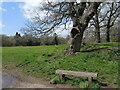
9
Oldbury Court Estate
Path up from the Frome Valley
Image: © norman griffin
Taken: 25 Jan 2015
0.20 miles
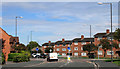
10
Bristol : Vassall Centre
The Vassall Centre was built in 1945 as a base for American soldiers and today is office space.
Image: © Lewis Clarke
Taken: 10 Aug 2022
0.21 miles