1
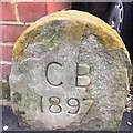
Old Boundary Marker
Municipal Boundary Marker against the end of the front dividing wall between nos. 23 and 25 on the south side of Sheppard Road. This was the boundary between Bristol and Mangotsfield, but is now entirely in Bristol. Inscribed C B / 1897.
Milestone Society National ID: GL_BRIS05pb
Image: © S Kosciow
Taken: 20 Apr 2019
0.08 miles
2
Bristol : Downend Road A432
A road heading through the Bristol suburbs.
Image: © Lewis Clarke
Taken: 1 Feb 2013
0.09 miles
3
Old Boundary Marker by Cassell Road, Fishponds, Bristol
Parish Boundary Marker by the UC road, in parish of Bristol (City Of Bristol District), Cassell Road, Fishponds, next to junction with the A432, Downend Road, inset into wall.
Surveyed
Milestone Society National ID: GL_BSMAN01pb.
Image: © Milestone Society
Taken: Unknown
0.09 miles
4
Ordnance Survey Cut Mark
This OS cut mark can be found on No108 Downend Road. It marks a point 62.682m above mean sea level.
Image: © Adrian Dust
Taken: 28 Jul 2022
0.10 miles
5
Bristol : Stanbury Avenue
A small road between Staplehill Road and Downend Road.
Image: © Lewis Clarke
Taken: 1 Feb 2013
0.17 miles
6
Bristol : The Oldbury Court Inn
A pub on Gill Avenue.
Image: © Lewis Clarke
Taken: 10 Aug 2022
0.19 miles
7
Benchmark on the side of #26 Cassell Road
Ordnance Survey cut mark benchmark described on the Bench Mark Database at http://www.bench-marks.org.uk/bm48030
Image: © Roger Templeman
Taken: 9 Apr 2013
0.19 miles
8
Alley between #26 and #27 Cassell Road
There is an OS benchmark
Image on the right hand house at its junction with the brick wall under the hedge
Image: © Roger Templeman
Taken: 9 Apr 2013
0.19 miles
9
Ordnance Survey Cut Mark
This OS cut mark can be found on No26 Cassell Road. It marks a point 65.861m above mean sea level.
Image: © Adrian Dust
Taken: 28 Jul 2022
0.19 miles
10
2011 : Gill Avenue, Fishponds, Bristol
A mini roundabout at the junction with Delabere Avenue to the right and Willow Bed Avenue to the left.
Image: © Maurice Pullin
Taken: 19 Aug 2011
0.19 miles


