IMAGES TAKEN NEAR TO
Channons Hill, BRISTOL, BS16 2LY
Introduction
This page details the photographs taken nearby to Channons Hill, BS16 2LY by members of the Geograph project.
The Geograph project started in 2005 with the aim of publishing, organising and preserving representative images for every square kilometre of Great Britain, Ireland and the Isle of Man.

There are currently over 7.5m images from over14,400 individuals and you can help contribute to the project by visiting https://www.geograph.org.uk
Image Map (Loading...)


Getting Data...Please wait
Leaflet Map data © OpenStreetMap
Images are licensed for reuse under creativecommons.org/licenses/by-sa/2.0
Notes
- Clicking on the map will re-center to the selected point.
- The higher the marker number, the further away the image location is from the centre of the postcode.
Image Listing (43 Images Found)
Images are licensed for reuse under creativecommons.org/licenses/by-sa/2.0
Image
Details
Distance
1
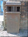
A little piece of old Bristol iron
They were a common sight in the past. Edward Crawford began an iron foundry and was a scale beam maker in Bristol by around 1881. The business seems to have made a range of iron products, including this ground vent, up until 1912. See Image] for a contextual view.
Image: © Neil Owen
Taken: 3 Apr 2023
0.03 miles
2
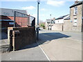
The corner of Channon's Hill
Formerly the site of a works, this spot has an old iron vent on the pavement. See Image] for a closer look.
Image: © Neil Owen
Taken: 3 Apr 2023
0.03 miles
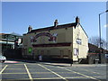
4
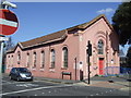
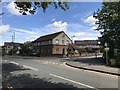
The Farriers Arms is due to go
This pub on the junction of the main road has been occupied for over 200 years. It first became known as a smithy in the early 1800s, with the resident working at one of three tenements leased by the Duchess Dowager of Beaufort. As time went on it was bought by another family who carried on the ironworking, but also offered beer by 1867. Over more time the smithy work stopped and the victuals became the prime source of income; the buildings became a garage - adjoining the pub, but which has been demolished for road-widening in the 1970s. Still the Farriers Arms carried on but, eventually closed in October 2010. It has lain disused and derelict ever since and was a target for demolition.
Image: © Neil Owen
Taken: 3 Apr 2023
0.05 miles
6
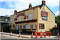
Farrier's Arms
Closed pub on Fishponds Road, next to a large Morrison's supermarket.
Image: © David Lally
Taken: 26 Jul 2011
0.05 miles
7
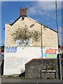
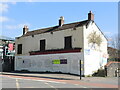
The side of the Farriers Arms
The pub has closed and the side of the building no longer has a garage business adjoining it, hence the painters have moved in.
Image: © Neil Owen
Taken: 3 Apr 2023
0.06 miles
8
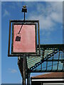
Folded Arms
The old Farriers Arms sign is as invisible as the regulars: the pub shut and has pretty much been left derelict. Morrisons built a large new store right beside the old pub (hence the canopy behind) and have their eyes on demolishing it to create more opportunity. Locals and the council are currently resisting.
Image: © Neil Owen
Taken: 3 Apr 2023
0.06 miles
10
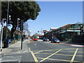
Junction of Station Avenue and Channon's Hill
Image: © don cload
Taken: 2 Jun 2018
0.07 miles