IMAGES TAKEN NEAR TO
Vassall Road, BRISTOL, BS16 2LW
Introduction
This page details the photographs taken nearby to Vassall Road, BS16 2LW by members of the Geograph project.
The Geograph project started in 2005 with the aim of publishing, organising and preserving representative images for every square kilometre of Great Britain, Ireland and the Isle of Man.

There are currently over 7.5m images from over14,400 individuals and you can help contribute to the project by visiting https://www.geograph.org.uk
Image Map (Loading...)


Getting Data...Please wait
Leaflet Map data © OpenStreetMap
Images are licensed for reuse under creativecommons.org/licenses/by-sa/2.0
Notes
- Clicking on the map will re-center to the selected point.
- The higher the marker number, the further away the image location is from the centre of the postcode.
Image Listing (27 Images Found)
Images are licensed for reuse under creativecommons.org/licenses/by-sa/2.0
Image
Details
Distance
1
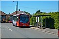
Bristol : Gill Avenue
Looking along Gill Avenue and towards the bus stop.
Image: © Lewis Clarke
Taken: 10 Aug 2022
0.03 miles
2
Bristol : Gill Avenue
Looking along Gill Avenue.
Image: © Lewis Clarke
Taken: 10 Aug 2022
0.07 miles
3
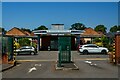
Bristol : Vassall Centre
The Vassall Centre was built in 1945 as a base for American soldiers and today is office space.
Image: © Lewis Clarke
Taken: 10 Aug 2022
0.07 miles
4
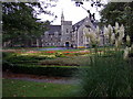
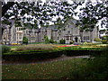
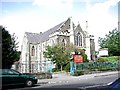
St Matthias campus, Fishponds
The college was built in the C19 as a teacher training facility for women, it then became part of Bristol Polytechnic and now houses the humanities, psychology and social sciences departments of the University of West of England.
The grounds are laid out with flower beds and specimen trees.
Image: © Natasha Ceridwen de Chroustchoff
Taken: 2 Jan 2007
0.11 miles
5
St Matthias, Fishponds
The warden's house on the north side of the campus.
St Matthias is one of UWE's four sites in Bristol.
Image: © Natasha Ceridwen de Chroustchoff
Taken: 2 Jan 2007
0.11 miles
6
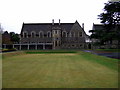
St Matthias, south side
The Victorian Gothic buildings with baronial touches range around three sides of the campus. The more modern additions extend to the north.
Image: © Natasha Ceridwen de Chroustchoff
Taken: 2 Jan 2007
0.13 miles
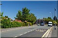
7
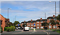
2011 : Gill Avenue, Fishponds, Bristol
A mini roundabout at the junction with Delabere Avenue to the right and Willow Bed Avenue to the left.
Image: © Maurice Pullin
Taken: 19 Aug 2011
0.13 miles
8
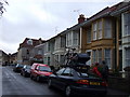
Elfin Road, Fishponds
Residential street bordering the St Matthias campus of the University of the West of England. Many of these houses are student accommodation.
Image: © Natasha Ceridwen de Chroustchoff
Taken: 2 Jan 2007
0.15 miles
10
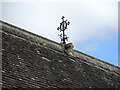
Rooftop feature of St Matthias chapel
A small decorative feature on the ridge of the chapel roof.
Image: © Neil Owen
Taken: 3 Apr 2023
0.16 miles