IMAGES TAKEN NEAR TO
Comyn Walk, BRISTOL, BS16 2JL
Introduction
This page details the photographs taken nearby to Comyn Walk, BS16 2JL by members of the Geograph project.
The Geograph project started in 2005 with the aim of publishing, organising and preserving representative images for every square kilometre of Great Britain, Ireland and the Isle of Man.

There are currently over 7.5m images from over14,400 individuals and you can help contribute to the project by visiting https://www.geograph.org.uk
Image Map
Images are licensed for reuse under creativecommons.org/licenses/by-sa/2.0
Notes
- Clicking on the map will re-center to the selected point.
- The higher the marker number, the further away the image location is from the centre of the postcode.
Image Listing (44 Images Found)
Images are licensed for reuse under creativecommons.org/licenses/by-sa/2.0
Image
Details
Distance
1
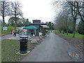
Main entrance drive to Oldbury Court, Bristol
Refreshments kiosk in the foreground.
Image: © Anthony O'Neil
Taken: 18 Nov 2010
0.09 miles
3
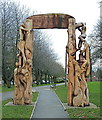
Carved wooden archway at Oldbury Court, Bristol
Image: © Anthony O'Neil
Taken: 18 Nov 2010
0.11 miles
4
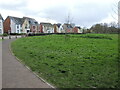
Warneford Road landscaping
New housing forms a semi-circular boundary with a green space in front of it. See Image] for a better look at the sunken landscaping.
Image: © Neil Owen
Taken: 13 Apr 2023
0.11 miles
5
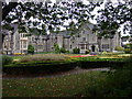
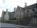
St Matthias, Fishponds
The warden's house on the north side of the campus.
St Matthias is one of UWE's four sites in Bristol.
Image: © Natasha Ceridwen de Chroustchoff
Taken: 2 Jan 2007
0.12 miles
6
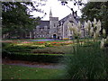
St Matthias campus, Fishponds
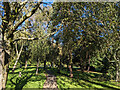
The college was built in the C19 as a teacher training facility for women, it then became part of Bristol Polytechnic and now houses the humanities, psychology and social sciences departments of the University of West of England.
The grounds are laid out with flower beds and specimen trees.
Image: © Natasha Ceridwen de Chroustchoff
Taken: 2 Jan 2007
0.12 miles
7
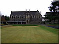
St Matthias, south side
The Victorian Gothic buildings with baronial touches range around three sides of the campus. The more modern additions extend to the north.
Image: © Natasha Ceridwen de Chroustchoff
Taken: 2 Jan 2007
0.12 miles
8
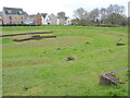
Sunken arena by Warneford Road
It seems to be a balancing pond, with culverting, set in front of the new houses. However, the levels and stone structures also give the place the feel of an arena. Would it be a popular local facility in drier times?
Image: © Neil Owen
Taken: 13 Apr 2023
0.14 miles
9
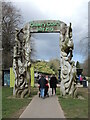
Entering Vassal's Park
Otherwise known as the Oldbury Court Estate and in the centre is a towering wooden sculpture, surmounted by lively figures. The park is a very popular one and recently has been granted £500,000 for upkeep and repairs.
Image: © Neil Owen
Taken: 13 Apr 2023
0.14 miles
10
Avanti Gardens School
This establishment began life in September, 1853, as the Gloucester and Bristol Diocesan Training School for school mistresses - a female only college. As proper schooling became more enshrined in statute law, it was necessary to develop and supply qualified teachers to the Church of England's voluntary elementary schools. Discipline was strict and rigorous, as was the Anglican way, and was largely self-funded - allowing it to remain clear of state controls.
The school became the College of St Matthias in 1955 and was part of the new approach to education. In 1972 it merged with Bristol Polytechnic, later to move from the site to a new one in Frenchay. By 2010 the St Matthias Campus was run down and finally sold off in 2014. It is now the Avanti Gardens School, an independent organisation.
Image: © Neil Owen
Taken: 3 Apr 2023
0.15 miles