IMAGES TAKEN NEAR TO
Oatley Way, BRISTOL, BS16 2FU
Introduction
This page details the photographs taken nearby to Oatley Way, BS16 2FU by members of the Geograph project.
The Geograph project started in 2005 with the aim of publishing, organising and preserving representative images for every square kilometre of Great Britain, Ireland and the Isle of Man.

There are currently over 7.5m images from over14,400 individuals and you can help contribute to the project by visiting https://www.geograph.org.uk
Image Map
Images are licensed for reuse under creativecommons.org/licenses/by-sa/2.0
Notes
- Clicking on the map will re-center to the selected point.
- The higher the marker number, the further away the image location is from the centre of the postcode.
Image Listing (59 Images Found)
Images are licensed for reuse under creativecommons.org/licenses/by-sa/2.0
Image
Details
Distance
1

Cupboard love
Equine resident of suburbia
Image: © Anthony O'Neil
Taken: 22 Jan 2021
0.07 miles
2
Avanti Gardens School
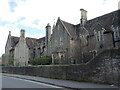
This establishment began life in September, 1853, as the Gloucester and Bristol Diocesan Training School for school mistresses - a female only college. As proper schooling became more enshrined in statute law, it was necessary to develop and supply qualified teachers to the Church of England's voluntary elementary schools. Discipline was strict and rigorous, as was the Anglican way, and was largely self-funded - allowing it to remain clear of state controls.
The school became the College of St Matthias in 1955 and was part of the new approach to education. In 1972 it merged with Bristol Polytechnic, later to move from the site to a new one in Frenchay. By 2010 the St Matthias Campus was run down and finally sold off in 2014. It is now the Avanti Gardens School, an independent organisation.
Image: © Neil Owen
Taken: 3 Apr 2023
0.09 miles
4
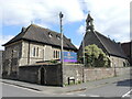
Avanti Gardens School
Occupying the former Diocesan Training College of St Matthias, the school in an independent trust. The chapel with the small belfry is St Mattias, which became used as the college's later name.
Image: © Neil Owen
Taken: 3 Apr 2023
0.10 miles
5
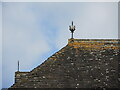
Ring feature on St Matthias chapel
The chapel was part of the old Diocesan Training College of the mid-nineteenth century, which trained women to become headmistresses in Church of England schools. It has a few small details on the roof ridgeline, including this crown and sword design.
Image: © Neil Owen
Taken: 3 Apr 2023
0.11 miles
6
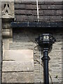
Drain with a date
As in common with many churches, the drains and guttering bears a date. In this instance of the old Diocesan Training College (later St Matthias, then Bristol Polytechnic), the chapel was built about the same time as the rest of the site. Also note the mesh lining the gutters, stopping things from dropping below.
Image: © Neil Owen
Taken: 3 Apr 2023
0.11 miles
7
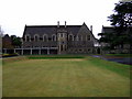
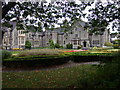
St Matthias, south side
The Victorian Gothic buildings with baronial touches range around three sides of the campus. The more modern additions extend to the north.
Image: © Natasha Ceridwen de Chroustchoff
Taken: 2 Jan 2007
0.11 miles
8
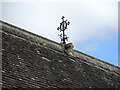
Rooftop feature of St Matthias chapel
A small decorative feature on the ridge of the chapel roof.
Image: © Neil Owen
Taken: 3 Apr 2023
0.11 miles
9
Catching the sun
Green energy in Fishponds
Image: © Anthony O'Neil
Taken: 22 Jan 2021
0.11 miles
10
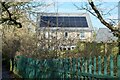
St Matthias, Fishponds
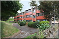
The warden's house on the north side of the campus.
St Matthias is one of UWE's four sites in Bristol.
Image: © Natasha Ceridwen de Chroustchoff
Taken: 2 Jan 2007
0.12 miles