IMAGES TAKEN NEAR TO
Manor Road, BRISTOL, BS16 2EN
Introduction
This page details the photographs taken nearby to Manor Road, BS16 2EN by members of the Geograph project.
The Geograph project started in 2005 with the aim of publishing, organising and preserving representative images for every square kilometre of Great Britain, Ireland and the Isle of Man.

There are currently over 7.5m images from over14,400 individuals and you can help contribute to the project by visiting https://www.geograph.org.uk
Image Map
Images are licensed for reuse under creativecommons.org/licenses/by-sa/2.0
Notes
- Clicking on the map will re-center to the selected point.
- The higher the marker number, the further away the image location is from the centre of the postcode.
Image Listing (45 Images Found)
Images are licensed for reuse under creativecommons.org/licenses/by-sa/2.0
Image
Details
Distance
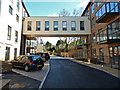
1
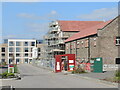
Napoleon Avenue
This site is currently being developed for new housing. However, the site is also reusing some of the older original buildings of what was then the Bristol Lunatic Asylum.
Image: © Neil Owen
Taken: 3 Apr 2023
0.07 miles
2
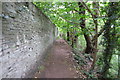
Along the Frome (9)
Path, Blackberry Hill
Image: © Anthony O'Neil
Taken: 4 Jun 2020
0.16 miles
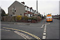
3
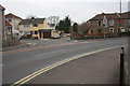
4-way junction
View from Snowdon Road with Channons Hill right, Adelaide Place ahead and Pound Lane left
Image: © Roger Templeman
Taken: 9 Apr 2013
0.17 miles
4

Along the Frome (10)
Steep riverside path
Image: © Anthony O'Neil
Taken: 4 Jun 2020
0.17 miles
5
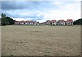
Along the Frome (8)
Open space with bijoux houses
Image: © Anthony O'Neil
Taken: 4 Jun 2020
0.17 miles
7
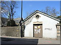
Easy power
An electricity substation on Blackberry Hill has a cryptic graffito.
Image: © Neil Owen
Taken: 3 Apr 2023
0.19 miles
8
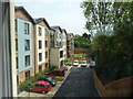
The Quarry Care Home
Fishponds, Bristol
Image: © Anthony O'Neil
Taken: 30 May 2016
0.19 miles
9
Houses of Lambrook Road at Eastbury Road junction
Image: © Roger Templeman
Taken: 9 Apr 2013
0.20 miles
10

Ordnance Survey Cut Mark
This OS cut mark can be found on the NE angle of Glenside Hospital Church. It marks a point 52.746m above mean sea level.
Image: © Adrian Dust
Taken: 27 Jul 2022
0.20 miles