IMAGES TAKEN NEAR TO
Redhill Close, BRISTOL, BS16 2AH
Introduction
This page details the photographs taken nearby to Redhill Close, BS16 2AH by members of the Geograph project.
The Geograph project started in 2005 with the aim of publishing, organising and preserving representative images for every square kilometre of Great Britain, Ireland and the Isle of Man.

There are currently over 7.5m images from over14,400 individuals and you can help contribute to the project by visiting https://www.geograph.org.uk
Image Map
Images are licensed for reuse under creativecommons.org/licenses/by-sa/2.0
Notes
- Clicking on the map will re-center to the selected point.
- The higher the marker number, the further away the image location is from the centre of the postcode.
Image Listing (26 Images Found)
Images are licensed for reuse under creativecommons.org/licenses/by-sa/2.0
Image
Details
Distance
1
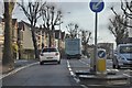
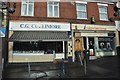
Bristol : Fishponds Road
Fishponds Road in Bristol with trees on the roadside and a bollard in view.
Image: © Lewis Clarke
Taken: 1 Feb 2013
0.10 miles
5
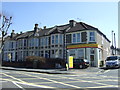
Bristol : C.G Cullimore & Insperations
A butchers and unisex hair salon side by side in Fishponds Road.
Image: © Lewis Clarke
Taken: 1 Feb 2013
0.12 miles

7
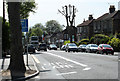
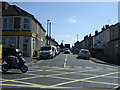
2011 : A432 Fishponds Road, Bristol with plane trees
Looking west at the end of Drummond Road.
A No.48 First Direct bus from Emersons Green and Downend heads toward Eastville and the city centre.
Image: © Maurice Pullin
Taken: 2 May 2011
0.13 miles
9
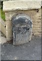
Old Milestone by the A432, Fishponds Road, Bristol parish
Metal plate attached to stone post by the A432, in parish of BRISTOL (CITY OF BRISTOL District), Fishponds Road, by junction with Oakdene Avenue, in front of wall of No 341, on North side of road. Bristol incised iron plate, erected by the Bristol turnpike trust in the 19th century.
Inscription reads:-
To
Briftol
2
Milestone Society National ID: GL_BRSY02.
Image: © M Faherty
Taken: 6 Mar 2015
0.15 miles
10
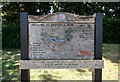
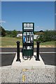
At Eastville Park (5)
Information board
Image: © Anthony O'Neil
Taken: 31 May 2020
0.15 miles