IMAGES TAKEN NEAR TO
Pearces Hill, BRISTOL, BS16 1LW
Introduction
This page details the photographs taken nearby to Pearces Hill, BS16 1LW by members of the Geograph project.
The Geograph project started in 2005 with the aim of publishing, organising and preserving representative images for every square kilometre of Great Britain, Ireland and the Isle of Man.

There are currently over 7.5m images from over14,400 individuals and you can help contribute to the project by visiting https://www.geograph.org.uk
Image Map
Images are licensed for reuse under creativecommons.org/licenses/by-sa/2.0
Notes
- Clicking on the map will re-center to the selected point.
- The higher the marker number, the further away the image location is from the centre of the postcode.
Image Listing (93 Images Found)
Images are licensed for reuse under creativecommons.org/licenses/by-sa/2.0
Image
Details
Distance
1
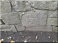
Ordnance Survey Cut Mark
This OS cut mark can be found on the wall SW side of Pearces Hill. It marks a point 48.363m above mean sea level.
Image: © Adrian Dust
Taken: 30 Nov 2022
0.03 miles
2
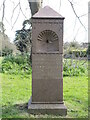
In honour of Victoria's sixtieth
This drinking fountain marks the sixtieth year of her reign in 1897 and was provided by Francis F. and Alice Tuckett.
The Tucketts were a prominent family in Frenchay in the nineteenth and early twentieth centuries and were staunch Quakers. Francis Tuckett (1803-68) was a landowner and an expert botanist; he imported and raised many of the trees specimens in the Frenchay and Downend area. His son, Francis F., followed in his footsteps and also made a name for himself as a mountaineer.
Image: © Neil Owen
Taken: 13 Apr 2023
0.04 miles
3
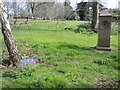
Spring by the fountain
Spring has arrived in a hurry this year and the bluebells are particularly eye-catching. Beside the natural beauty is a drinking fountain. See Image] for a closer look at the provision.
Image: © Neil Owen
Taken: 13 Apr 2023
0.04 miles
4
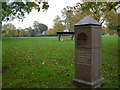
Frenchay, drinking fountain
On Frenchay Common.
Image: © Mike Faherty
Taken: 29 Oct 2010
0.04 miles
5
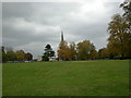
Frenchay Common
Looking towards St. John the Baptist's Church.
Image: © Mike Faherty
Taken: 29 Oct 2010
0.04 miles
6
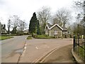
Frenchay, South Lodge
On Beckspool Road; former lodge to Frenchay Park.
Image: © Mike Faherty
Taken: 15 Mar 2018
0.05 miles
7

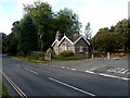
Pearces Hill, Frenchay
This NW section of Pearces Hill is deceptively flat. The road merits its name further ahead.
Image: © Jaggery
Taken: 18 Oct 2012
0.05 miles
8
CLIC Cottage, Frenchay
Viewed across Beckspool Road at entrance C Blue http://www.geograph.org.uk/photo/3710169 to Frenchay Hospital.
CLIC is the acronym for the charity Cancer and Leukemia in Children.
CLIC restored an old lodge to offer free accommodation to the parents of sick children in the hospital.
Image: © Jaggery
Taken: 18 Oct 2012
0.05 miles
9

2011 : Across Frenchay Common
Once the home of Frenchay Cricket Club, spent many a happy saturday afternoon here.
The cricket club has long since moved to a site near the junction of the Avon Ring Road http://frenchay.play-cricket.com/home/aboutUs.asp and the M32 motorway. Easier to get to but...
Image: © Maurice Pullin
Taken: 2 Aug 2011
0.06 miles
10
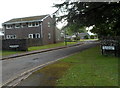
The Newlands, Frenchay
Cul-de-sac on the south side of the road named Begbrook Park.
Image: © Jaggery
Taken: 18 Oct 2012
0.07 miles