IMAGES TAKEN NEAR TO
Begbrook Lane, BRISTOL, BS16 1HP
Introduction
This page details the photographs taken nearby to Begbrook Lane, BS16 1HP by members of the Geograph project.
The Geograph project started in 2005 with the aim of publishing, organising and preserving representative images for every square kilometre of Great Britain, Ireland and the Isle of Man.

There are currently over 7.5m images from over14,400 individuals and you can help contribute to the project by visiting https://www.geograph.org.uk
Image Map
Images are licensed for reuse under creativecommons.org/licenses/by-sa/2.0
Notes
- Clicking on the map will re-center to the selected point.
- The higher the marker number, the further away the image location is from the centre of the postcode.
Image Listing (35 Images Found)
Images are licensed for reuse under creativecommons.org/licenses/by-sa/2.0
Image
Details
Distance
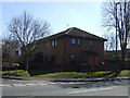
1
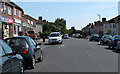
2011 : Frome Valley Road, Broomhill
A post war development with a row of shops.
Image: © Maurice Pullin
Taken: 2 May 2011
0.13 miles
2
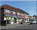
2011 : Post Office and shops, Frome Valley Road, Broomhill
Also a convenience store, an off licence, a pharmacy and a car showroom.
Image: © Maurice Pullin
Taken: 2 May 2011
0.14 miles
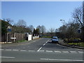
3
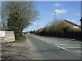
2011 : B4058 traffic lights on Frenchay Park Road
At Broomhill looking north toward Hambrook and Winterbourne.
Stoke Lane is to the left at the traffic lights.
Image: © Maurice Pullin
Taken: 2 May 2011
0.14 miles
4

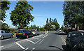
Bristol : Stoke Lane
Looking along Stoke Lane from Frenchay Park Road.
Image: © Lewis Clarke
Taken: 12 Jun 2016
0.15 miles
5
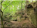
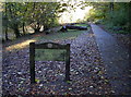
Path through quarry by the Frome
A path climbs away from the riverside path through this Pennant Stone quarry.
Image: © Derek Harper
Taken: 25 Sep 2014
0.16 miles
8
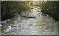
River Frome in spate (1)
From Ha'penny Bridge
Image: © Anthony O'Neil
Taken: 22 Jan 2021
0.19 miles
9
Oldbury Estate
Snuff Mills was bought by the council in 1926 and took in a number of old mill sites and part of the Oldbury Court Estate. The latter was mentioned in the Domesday Book of 1066 and over its history passed through a number of different owners. The last were the Vassalls family, but they left no male heir in 1936 and sold the land to Bristol Corporation. In 1948 a fire swept through the coaching house and stables; a report of the damage revealed the house itself was in serious condition and was subsequently demolished.
Image: © Neil Owen
Taken: 5 Nov 2012
0.20 miles