IMAGES TAKEN NEAR TO
Blackberry Hill, BRISTOL, BS16 1EG
Introduction
This page details the photographs taken nearby to Blackberry Hill, BS16 1EG by members of the Geograph project.
The Geograph project started in 2005 with the aim of publishing, organising and preserving representative images for every square kilometre of Great Britain, Ireland and the Isle of Man.

There are currently over 7.5m images from over14,400 individuals and you can help contribute to the project by visiting https://www.geograph.org.uk
Image Map
Images are licensed for reuse under creativecommons.org/licenses/by-sa/2.0
Notes
- Clicking on the map will re-center to the selected point.
- The higher the marker number, the further away the image location is from the centre of the postcode.
Image Listing (72 Images Found)
Images are licensed for reuse under creativecommons.org/licenses/by-sa/2.0
Image
Details
Distance
1
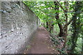
Along the Frome (9)
Path, Blackberry Hill
Image: © Anthony O'Neil
Taken: 4 Jun 2020
0.05 miles
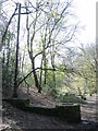
2
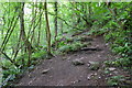
Along the Frome (10)
Steep riverside path
Image: © Anthony O'Neil
Taken: 4 Jun 2020
0.06 miles
3
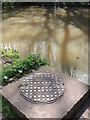
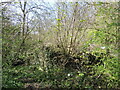
Foul by the Frome
A large circular manhole cover stands ominously right beside the River Frome. The cover bears the text 'Frome Valley foulsewer', rather perversely.
Broads was a builder's merchant, established at Paddington Dock, London, in 1882; they had an iron foundry at Hanwell, West London.
Image: © Neil Owen
Taken: 13 Apr 2023
0.09 miles
4
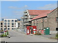
Napoleon Avenue
This site is currently being developed for new housing. However, the site is also reusing some of the older original buildings of what was then the Bristol Lunatic Asylum.
Image: © Neil Owen
Taken: 3 Apr 2023
0.10 miles
5
A stink pipe and a sewer by the River Frome
It is something of a surprise to see a sewer system this close to the river. The vent pipe bears the mark of William E. Farrer: he started a Birmingham foundry, established in 1896, and produced many sewer and sanitary ironmongery, some of which included supplying railways. They were merged over time and are now a part of the Montgomery Watson Harza group.
Image: © Neil Owen
Taken: 13 Apr 2023
0.11 miles
6
Keeping the fumes above the pathway
A stink pipe reaches high into the tree canopy to allow sewer fumes to dissipate far from walkers.
Image: © Neil Owen
Taken: 13 Apr 2023
0.11 miles
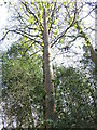
7
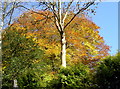
An autumn crown
The somewhat disturbed summer weather has caused lots of odd responses from the natural environment. Here a tree seems to be changing colour from the top downwards. A sort of traffic light effect, possibly?
Image: © Neil Owen
Taken: 5 Nov 2012
0.11 miles
8
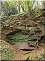
Quarry by the Frome
A Pennant stone quarry near Half Penny Bridge. Pennant stone is described as a "hard, fine grained, blue/grey coloured sandstone" and was used for roofing http://thesaurus.english-heritage.org.uk/thesaurus.asp?thes_no=129 .
Image: © Derek Harper
Taken: 26 Oct 2014
0.11 miles
9
Barely a trace
The greenery is quick to heal and conceal the past. Underneath the Spring growth is a ruined building. In the past this was Witherly's Mill - this site seems to have records of a grist mill from before 1498. By 1790 it was owned by a tobacconist and making snuff - the area is popularly known as Snuff Mills due to number that did. Two years later and the mill was owned by the first members of the Wills tobacco family of Bristol, again producing snuff. In 1843 the mill was bought by Thomas Saint, who converted it to make flocks and carding wool. The last owner was a Thomas Lusty, who ran it until about 1877. The disused buildings were largely demolished in the 1930s.
Image: © Neil Owen
Taken: 13 Apr 2023
0.11 miles
10
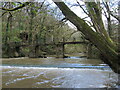
Footbridge over the Frome
The river is in good flow and the shallow weir is just about visible.
Image: © Neil Owen
Taken: 13 Apr 2023
0.14 miles