IMAGES TAKEN NEAR TO
Wickham Hill, BRISTOL, BS16 1DG
Introduction
This page details the photographs taken nearby to Wickham Hill, BS16 1DG by members of the Geograph project.
The Geograph project started in 2005 with the aim of publishing, organising and preserving representative images for every square kilometre of Great Britain, Ireland and the Isle of Man.

There are currently over 7.5m images from over14,400 individuals and you can help contribute to the project by visiting https://www.geograph.org.uk
Image Map
Images are licensed for reuse under creativecommons.org/licenses/by-sa/2.0
Notes
- Clicking on the map will re-center to the selected point.
- The higher the marker number, the further away the image location is from the centre of the postcode.
Image Listing (75 Images Found)
Images are licensed for reuse under creativecommons.org/licenses/by-sa/2.0
Image
Details
Distance
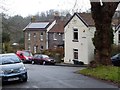
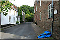
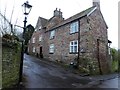
2
Houses on Wickham Hill
The view is across Blackberry Hill at the Wickham Hill junction. The nearest house is #6. There is an OS benchmark Image on the roadside wall just left of the electricity pole.
Image: © Roger Templeman
Taken: 9 Apr 2013
0.01 miles
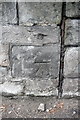
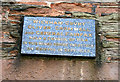
3
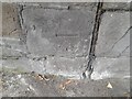
Ordnance Survey Cut Mark
This OS cut mark can be found on the wall of No6 Wickham Hill. It marks a point 27.624m above mean sea level.
Image: © Adrian Dust
Taken: 27 Jul 2022
0.02 miles
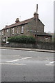
4
Benchmark on wall of Blackberry Hill at Wickham Hill junction
Ordnance Survey cut mark benchmark described on the Bench Mark Database at http://www.bench-marks.org.uk/bm48025
Image: © Roger Templeman
Taken: 9 Apr 2013
0.02 miles
5
Wickham Court
The maps give this name to this short off-shot of Wickham Hill. More accurately it is the name of the grade II* listed house on the right http://list.english-heritage.org.uk/resultsingle.aspx?uid=1220291 .
Image: © David Lally
Taken: 5 Aug 2011
0.04 miles
6
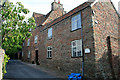
Wickham Court
A Grade II* listed http://list.english-heritage.org.uk/resultsingle.aspx?uid=1220291 house on Wickham Hill. According to the listing text and a plaque above the door Oliver Cromwell and Thomas Fairfax held council here in 1645 before the march on Bristol. At that time Wickham Hill formed part of the main route to Bristol from Gloucester.
Image: © David Lally
Taken: 5 Aug 2011
0.04 miles
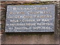
7
Plaque on Wickham Court
It reads:
“Wickham Court”
Oliver Cromwell and General Fairfax
Held a Council of War
In this house before the attack
On Bristol in Sept. 1645
See Image
Image: © David Lally
Taken: 5 Aug 2011
0.04 miles
8
Wickham Court Plaque
Plaque above the door of Wickham Court Image
Image: © Eirian Evans
Taken: 19 Feb 2018
0.04 miles
9
Wickham Court
Here a Council of War was held by Oliver Cromwell and General Fairfax before the attack on Bristol in 1645. On the west side of Wickham Hill, as it descends to Eastville Park.
Image: © Eirian Evans
Taken: 19 Feb 2018
0.04 miles
10
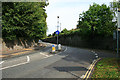
Blackberry Hill
Taken from the top of Wickham Hill.
Image: © David Lally
Taken: 5 Aug 2011
0.04 miles