IMAGES TAKEN NEAR TO
Duchess Way, BRISTOL, BS16 1BZ
Introduction
This page details the photographs taken nearby to Duchess Way, BS16 1BZ by members of the Geograph project.
The Geograph project started in 2005 with the aim of publishing, organising and preserving representative images for every square kilometre of Great Britain, Ireland and the Isle of Man.

There are currently over 7.5m images from over14,400 individuals and you can help contribute to the project by visiting https://www.geograph.org.uk
Image Map
Images are licensed for reuse under creativecommons.org/licenses/by-sa/2.0
Notes
- Clicking on the map will re-center to the selected point.
- The higher the marker number, the further away the image location is from the centre of the postcode.
Image Listing (62 Images Found)
Images are licensed for reuse under creativecommons.org/licenses/by-sa/2.0
Image
Details
Distance
1
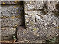
Ordnance Survey Cut Mark
This OS cut mark can be found on at the entrance to Stoke Park on Frenchay Park Road. It marks a point 25.399m above mean sea level.
Image: © Adrian Dust
Taken: 27 Jul 2022
0.03 miles
2
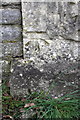
Benchmark on gatepost at entrance to Stoke Park Estate
Ordnance Survey cut mark benchmark described on the Bench Mark Database at http://www.bench-marks.org.uk/bm48023
Image: © Roger Templeman
Taken: 9 Apr 2013
0.03 miles
3
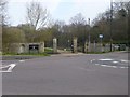
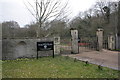
Gate to Dower House footpath
This gate lies next to the roundabout at the bottom of Broom Hill. The footpath commences here, leads under the M32 and ascends to the Stoke Park estate, next to the Dower House.
Image: © Brett Norris
Taken: 17 Aug 2009
0.03 miles
4
Broomhill, Duchess Gate
On Frenchay Park Road, the entrance to Stoke Park Estate. http://www.bristol.gov.uk/page/leisure-and-culture/stoke-park-estate
Image: © Mike Faherty
Taken: 30 Mar 2014
0.03 miles
5
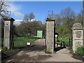
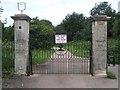
The Duchess Gates
An entrance to the Stoke Park estate bears some relics of the private past. These days the area is an open public facility, with the M32 carving straight through the middle of it. A lodge used to stand just to the right of the gates.
Image: © Neil Owen
Taken: 13 Apr 2023
0.03 miles
7
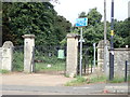
Entrance to Stoke Park Estate, Frenchay Park Road
There is an OS benchmark Image on the wall pier/gatepost immediately right of the notice
Image: © Roger Templeman
Taken: 9 Apr 2013
0.04 miles
8
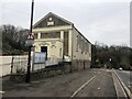
Stapleton Chapel
On Broom Hill, Stapleton. Built in 1833 for the Baptist church.
Image: © Eirian Evans
Taken: 21 Jan 2022
0.06 miles
9
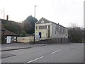
Stapleton Baptist Church
On Broom Hill, dated 1855: http://www.webassoc.org.uk/ChurchDetail.aspx?id=91
Image: © Mike Faherty
Taken: 30 Mar 2014
0.06 miles
10
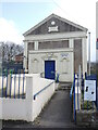
Stapleton Baptist Church
The church was established in 1833 and this church built two years later. It has served all these years and now belongs to the West of England Baptist Association. Inside the organ has been replaced by an electric piano and the old wooden pews are now replaced by comfortable seating.
Image: © Neil Owen
Taken: 13 Apr 2023
0.07 miles