IMAGES TAKEN NEAR TO
Park Street, BRISTOL, BS1 5NL
Introduction
This page details the photographs taken nearby to Park Street, BS1 5NL by members of the Geograph project.
The Geograph project started in 2005 with the aim of publishing, organising and preserving representative images for every square kilometre of Great Britain, Ireland and the Isle of Man.

There are currently over 7.5m images from over14,400 individuals and you can help contribute to the project by visiting https://www.geograph.org.uk
Image Map
Images are licensed for reuse under creativecommons.org/licenses/by-sa/2.0
Notes
- Clicking on the map will re-center to the selected point.
- The higher the marker number, the further away the image location is from the centre of the postcode.
Image Listing (1235 Images Found)
Images are licensed for reuse under creativecommons.org/licenses/by-sa/2.0
Image
Details
Distance
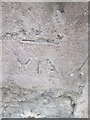
2
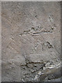
Benchmark at risk
The years have not been too kind to this mark (as described in the Benchmark Database -http://www.bench-marks.org.uk/bm28965 ); an odd infill of the datum line seems to have been made here. See Image] for a wider view.
Image: © Neil Owen
Taken: 26 Jul 2011
0.01 miles
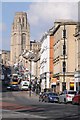
3
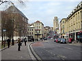
View up Park Street
With the university tower in the background, this shot is at the junction of Park Street with Great George Street. A badly damaged benchmark can be seen at the foot of the stonework -Image
Image: © Neil Owen
Taken: 26 Jul 2011
0.01 miles
4
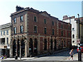
47 Park Street, Bristol
To a Georgian house of c1762, probably by Thomas Paty, a Victorian shopfront was applied, c1865, essentially an extravagantly tall and spindly arcade. Grade II listed.
At the time occupied by jewellers, Mappin & Webb.
Image: © Stephen Richards
Taken: 22 May 2012
0.01 miles
5
Park Street and the Wills Tower
View up Park Street to the Wills Memorial Tower, part of Bristol University.
Image: © Philip Halling
Taken: 28 Feb 2018
0.01 miles
6
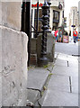
Ordnance Survey Cut Mark
This OS cut mark can be found on No47 Park Street. It marks a point 27.478m above mean sea level.
Image: © Adrian Dust
Taken: 5 Mar 2016
0.02 miles
7
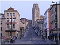
Park Street, Bristol
Looking up an almost empty Park Street (never terribly busy at seven o'clock on a bank holiday morning) dominated by the 215 ft gothic pile of the Wills Tower.
Image: © Chris Denny
Taken: 25 Apr 2011
0.02 miles
8
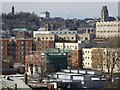
The Bristol skyline
The Bristol skyline viewed from Victoria Park, among the buildings of note, on the left is the Cabot Tower and on the right the Wills Tower. The three towers of the cathedral can also be seen in the centre in the middle distance.
Image: © Philip Halling
Taken: 2 Apr 2016
0.02 miles
9
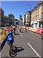
Let's Ride event, 2018
Heading up Park Street. The city centre was closed to traffic as thousands took the roads on their bikes
Image: © Eirian Evans
Taken: 9 Jul 2018
0.02 miles
10
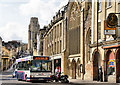
College Green and Park Street
Looking up the hill past St Mark's church towards the University.
Image: © Pierre Terre
Taken: 4 Jul 2009
0.02 miles