IMAGES TAKEN NEAR TO
Lime Kiln Road, BRISTOL, BS1 5AD
Introduction
This page details the photographs taken nearby to Lime Kiln Road, BS1 5AD by members of the Geograph project.
The Geograph project started in 2005 with the aim of publishing, organising and preserving representative images for every square kilometre of Great Britain, Ireland and the Isle of Man.

There are currently over 7.5m images from over14,400 individuals and you can help contribute to the project by visiting https://www.geograph.org.uk
Image Map
Images are licensed for reuse under creativecommons.org/licenses/by-sa/2.0
Notes
- Clicking on the map will re-center to the selected point.
- The higher the marker number, the further away the image location is from the centre of the postcode.
Image Listing (1541 Images Found)
Images are licensed for reuse under creativecommons.org/licenses/by-sa/2.0
Image
Details
Distance
1
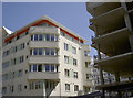
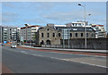
New phase
The old Bristol docks were once home to many heavy industries, as well as wharves. These have been cleared in recent years to provide new residential areas; work carries on another block along Capricorn Quay.
Image: © Neil Owen
Taken: 4 Jun 2013
0.02 miles
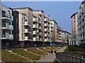
2
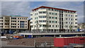
New apartment building - Bristol Harbour
This development is on the harbourside near the site of the old Gas Works.
Image: © Anthony O'Neil
Taken: 12 Jul 2008
0.02 miles
3
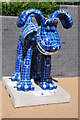
Gromit-o-Matic, Gromit No.52
Gromit-o-Matic, Gromit No.52, located at Brunel Mile, one of 80 Gromits currently on display in Bristol and its environs. Artist: Donough O'Malley.
Image: © Philip Halling
Taken: 18 Aug 2013
0.02 miles
4
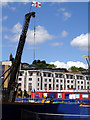
Harbourside Development
The Harbourside Development is on a brownfield site, and this is the next phase of development underway. The Cabot Tower Image is on the skyline.
Image: © Linda Bailey
Taken: 30 Jul 2006
0.03 miles
5
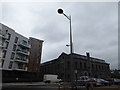
Temple Meads to Ashton Gate (94)
Lamppost in Anchor Street
Image: © Basher Eyre
Taken: 13 Feb 2016
0.03 miles
6
Bristol - Canon's Marsh
New housing development by the Floating Harbour.
Image: © Colin Smith
Taken: 23 Mar 2016
0.03 miles
7
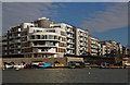
Apartments at Canon's Marsh
Bristol Harbour
Image: © Anthony O'Neil
Taken: 26 Oct 2015
0.03 miles
8
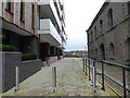
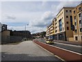
Temple Meads to Ashton Gate (95)
Cut through from Anchor Street to the Harbour Path
Image: © Basher Eyre
Taken: 13 Feb 2016
0.03 miles
9
Anchor Road
Former Gas Works building in the foreground at Canon's Marsh.
Image: © Anthony O'Neil
Taken: 15 Apr 2017
0.03 miles
10
Anchor Road
Looking along a wide road in Bristol between the Cathedral and floating harbour.
Image: © DS Pugh
Taken: 21 Aug 2019
0.03 miles