IMAGES TAKEN NEAR TO
Fairview Road, BRISTOL, BS15 9UT
Introduction
This page details the photographs taken nearby to Fairview Road, BS15 9UT by members of the Geograph project.
The Geograph project started in 2005 with the aim of publishing, organising and preserving representative images for every square kilometre of Great Britain, Ireland and the Isle of Man.

There are currently over 7.5m images from over14,400 individuals and you can help contribute to the project by visiting https://www.geograph.org.uk
Image Map (Loading...)


Getting Data...Please wait
Leaflet Map data © OpenStreetMap
Images are licensed for reuse under creativecommons.org/licenses/by-sa/2.0
Notes
- Clicking on the map will re-center to the selected point.
- The higher the marker number, the further away the image location is from the centre of the postcode.
Image Listing (19 Images Found)
Images are licensed for reuse under creativecommons.org/licenses/by-sa/2.0
Image
Details
Distance
1
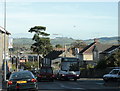
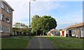
2009 : A420 Hill Street, Warmley Hill
Dropping down from Kingswood, the bus is the best way up.
On the horizon straight ahead, that row of trees on Freezing Hill Image
Image: © Maurice Pullin
Taken: 12 Oct 2009
0.04 miles
2
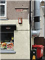
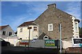
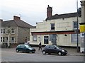
A crumbling sign on Hill Street
There are many older shops and houses along the main road, with a few still bearing some of the original features. This take-away seems to have had some attempt to retain the name, although things are crumbling somewhat.
In times past, there was a row of buildings along the same frontage to the right of the shop, but these have now been lost. The shop projects out from the rest of the street, which was opposite an old leather factory before the war.
Image: © Neil Owen
Taken: 4 Jul 2024
0.08 miles
3
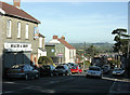
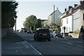
2009 : Do you think they do part exchange?
Looking down Warmley Hill from about half way up, a stiff climb from Warmley to Kingswood on the A420.
Image: © Maurice Pullin
Taken: 12 Oct 2009
0.09 miles
5
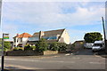
Honey Hill Road at the corner of High Street, Warmley
Image: © David Howard
Taken: 1 Jun 2019
0.12 miles
7
2009 : A420 Hill Street, looking west up Warmley Hill
Kingswood begins at the top of the hill.
Image: © Maurice Pullin
Taken: 12 Oct 2009
0.14 miles
8
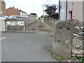
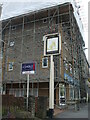
Hill Street milestone
It is natural to see an old stone with the plate missing - many have doubtless been melted down as scrap by the unscrupulous. It had marked Bristol as being four miles away. This one is on Hill Street in Kingswood, close to a lane which was created along with the modern housing beside it.
Image: © Neil Owen
Taken: 4 Jul 2024
0.15 miles
9
Kingswood: The former Highwayman
In 2011 the A420 road heading into Bristol was littered with dead pubs. This former Ansells outlet is one of them. This is the view from Honeyhill Road.
Image: © Nigel Cox
Taken: 25 Jun 2011
0.15 miles
10
A sign is all that's left
The large residential block is called Highwayman Court - a modern development on the site of the former Ansell's pub, The Highwayman. A fixture for many years in Kingswood, the pub closed in 2010, was demolished, and the offices and flats opened by 2015. All that remains is the old pub sign, now hanging forlornly and ghostly.
Image: © Neil Owen
Taken: 29 May 2024
0.15 miles