IMAGES TAKEN NEAR TO
Pettigrove Road, BRISTOL, BS15 9SN
Introduction
This page details the photographs taken nearby to Pettigrove Road, BS15 9SN by members of the Geograph project.
The Geograph project started in 2005 with the aim of publishing, organising and preserving representative images for every square kilometre of Great Britain, Ireland and the Isle of Man.

There are currently over 7.5m images from over14,400 individuals and you can help contribute to the project by visiting https://www.geograph.org.uk
Image Map (Loading...)


Getting Data...Please wait
Leaflet Map data © OpenStreetMap
Images are licensed for reuse under creativecommons.org/licenses/by-sa/2.0
Notes
- Clicking on the map will re-center to the selected point.
- The higher the marker number, the further away the image location is from the centre of the postcode.
Image Listing (10 Images Found)
Images are licensed for reuse under creativecommons.org/licenses/by-sa/2.0
Image
Details
Distance
1
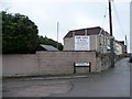
Back garden ripe for development, Mount Hill Road
A house for sale with planning permission for three new homes in the garden.
Image: © Christine Johnstone
Taken: 23 Mar 2013
0.17 miles
2
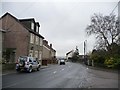
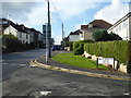
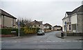
Mount Hill Road, Mount Hill
At the eastern junction with Hollyguest Road.
Image: © Christine Johnstone
Taken: 23 Mar 2013
0.18 miles
3
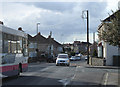
2011 : West on Mount Hill Road, Hanham
Image: © Maurice Pullin
Taken: 14 Feb 2011
0.19 miles
4
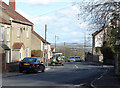
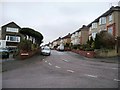
2011 : Cock Road, Hanham, Bristol
At the end of Mount Hill Road Cock Road drops away to the east from the dizzy heights of The Mount.
The western escarpment of the Cotswolds is in the distance somewhere south of Dyrham.
Image: © Maurice Pullin
Taken: 14 Feb 2011
0.19 miles
5
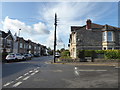
Junction of Cock Road and Owls Head Road, Kingswood
On an organised walk around mining remains in this part of Bristol. This was just a shot en passant.
Image: © Chris Allen
Taken: 19 Oct 2019
0.20 miles
6
Kelston Grove, Mount Hill
Looking west from Hollyguest Road.
Image: © Christine Johnstone
Taken: 23 Mar 2013
0.23 miles
7
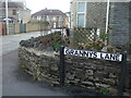
Grannys Lane
This lane is an old one - part of the original layout of roads in previous centuries. The houses are fairly recent arrivals. Further along the lane was the old Free Methodist Chapel, and later Misssion Hall.
Image: © Neil Owen
Taken: 23 Feb 2021
0.23 miles
8
2011 : Hollyguest Road, Mount Hill, Hanham
To the south of Mount Hill Road.
The view beyond is over the Avon Valley to farmland between Keynsham and Stockwood.
Image: © Maurice Pullin
Taken: 14 Feb 2011
0.24 miles
9
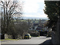
Granny's Lane
Looking south from the 102 metre spot height on Mount Hill Road.
Image: © Christine Johnstone
Taken: 23 Mar 2013
0.24 miles
10
Junction of Court Road and Mount Hill Road
It is hard to believe this area was once a significant coal field with many pits. There are now few clues.
Image: © Chris Allen
Taken: 19 Oct 2019
0.24 miles