IMAGES TAKEN NEAR TO
Courtney Road, BRISTOL, BS15 9RL
Introduction
This page details the photographs taken nearby to Courtney Road, BS15 9RL by members of the Geograph project.
The Geograph project started in 2005 with the aim of publishing, organising and preserving representative images for every square kilometre of Great Britain, Ireland and the Isle of Man.

There are currently over 7.5m images from over14,400 individuals and you can help contribute to the project by visiting https://www.geograph.org.uk
Image Map
Images are licensed for reuse under creativecommons.org/licenses/by-sa/2.0
Notes
- Clicking on the map will re-center to the selected point.
- The higher the marker number, the further away the image location is from the centre of the postcode.
Image Listing (3 Images Found)
Images are licensed for reuse under creativecommons.org/licenses/by-sa/2.0
Image
Details
Distance
1
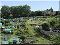
Lantern Bottom allotments
The allotments have found themselves increasingly surrounded by post-war housing, but remain a popular feature of the community.
Image: © Neil Owen
Taken: 4 Jul 2024
0.14 miles
2
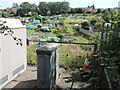
Power and plants in Lantern Bottom
The area has had allotments for a long time, even as the modern housing has encroached. Part of the growth of the population also required power, and an electricity sub-station was installed here.
Image: © Neil Owen
Taken: 4 Jul 2024
0.19 miles
3
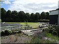
Kingswood and Hanham Bowling Club
The clubhouse and green are in the heart of Kingswood Park. In 2021, the club were acclaimed as the Bowls England Club of the Year.
Image: © Neil Owen
Taken: 4 Jul 2024
0.24 miles