IMAGES TAKEN NEAR TO
Dundry Close, BRISTOL, BS15 9QW
Introduction
This page details the photographs taken nearby to Dundry Close, BS15 9QW by members of the Geograph project.
The Geograph project started in 2005 with the aim of publishing, organising and preserving representative images for every square kilometre of Great Britain, Ireland and the Isle of Man.

There are currently over 7.5m images from over14,400 individuals and you can help contribute to the project by visiting https://www.geograph.org.uk
Image Map
Images are licensed for reuse under creativecommons.org/licenses/by-sa/2.0
Notes
- Clicking on the map will re-center to the selected point.
- The higher the marker number, the further away the image location is from the centre of the postcode.
Image Listing (24 Images Found)
Images are licensed for reuse under creativecommons.org/licenses/by-sa/2.0
Image
Details
Distance
1
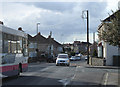
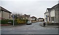
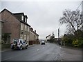
2011 : West on Mount Hill Road, Hanham
Image: © Maurice Pullin
Taken: 14 Feb 2011
0.13 miles
2
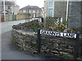
Grannys Lane
This lane is an old one - part of the original layout of roads in previous centuries. The houses are fairly recent arrivals. Further along the lane was the old Free Methodist Chapel, and later Misssion Hall.
Image: © Neil Owen
Taken: 23 Feb 2021
0.15 miles
3
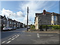
Junction of Court Road and Mount Hill Road
It is hard to believe this area was once a significant coal field with many pits. There are now few clues.
Image: © Chris Allen
Taken: 19 Oct 2019
0.15 miles
4
Back garden ripe for development, Mount Hill Road
A house for sale with planning permission for three new homes in the garden.
Image: © Christine Johnstone
Taken: 23 Mar 2013
0.16 miles
5
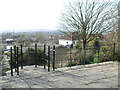
Granny's Lane
Looking south from the 102 metre spot height on Mount Hill Road.
Image: © Christine Johnstone
Taken: 23 Mar 2013
0.16 miles
6
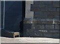
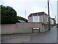
Ordnance Survey Cut Mark
This OS cut mark can be found on the north angle of the school on Hanham Road. It marks a point 110.697m above mean sea level.
Image: © Adrian Dust
Taken: 19 Jul 2021
0.19 miles
7
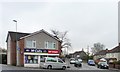
McColls corner shop
At the junction of Mount Hill and Hollyguest Roads.
Image: © Christine Johnstone
Taken: 23 Mar 2013
0.20 miles
8
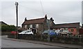
The Cross Keys, Hollyguest Road
The crossed keys refer to St Peter, but the church opposite is dedicated to the Ascension.
Image: © Christine Johnstone
Taken: 23 Mar 2013
0.20 miles
9
Mount Hill Road, Mount Hill
At the eastern junction with Hollyguest Road.
Image: © Christine Johnstone
Taken: 23 Mar 2013
0.21 miles
10
Where Wesley spoke to all
The origin of the Methodist movement is marked here on Hanham Mount. In 1739 John Wesley, along with the likes of George Whitfield and John Cennick the Moravian, held open-air services. The movement was disregarded by the establishment and prevented much of their work, particularly building a church. So Wesley preached in the open air to the many attendees, who were mainly from the coal-mining areas of Kingswood (then a separate region from Bristol).
This site is given over to a memorial, which includes this space where a pulpit once stood. Here Wesley would give a sermon on The Mount.
Image: © Neil Owen
Taken: 23 Feb 2021
0.21 miles