IMAGES TAKEN NEAR TO
Pillingers Road, BRISTOL, BS15 8DE
Introduction
This page details the photographs taken nearby to Pillingers Road, BS15 8DE by members of the Geograph project.
The Geograph project started in 2005 with the aim of publishing, organising and preserving representative images for every square kilometre of Great Britain, Ireland and the Isle of Man.

There are currently over 7.5m images from over14,400 individuals and you can help contribute to the project by visiting https://www.geograph.org.uk
Image Map
Images are licensed for reuse under creativecommons.org/licenses/by-sa/2.0
Notes
- Clicking on the map will re-center to the selected point.
- The higher the marker number, the further away the image location is from the centre of the postcode.
Image Listing (15 Images Found)
Images are licensed for reuse under creativecommons.org/licenses/by-sa/2.0
Image
Details
Distance
1
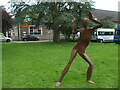
A man out in all seasons
A metal figure stands in the grounds of the Kingswood Foundation Estate. Previously the Kingswood Reformatory School, it is now home to several help charities and organisations.
Image: © Neil Owen
Taken: 29 May 2024
0.17 miles
2
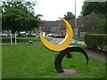
Sculpture in the old school
There are a couple of sculptures in the grounds of the former Kingswood Reformatory School - now home to the Creative Youth Network.
Image: © Neil Owen
Taken: 29 May 2024
0.17 miles
3
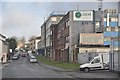
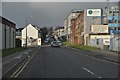
Kingswood : Moravian Road
Moravian Road between Hanham Road and Cecil Road.
Image: © Lewis Clarke
Taken: 1 Feb 2013
0.21 miles
4
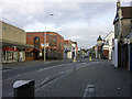
Regent Street Kingswood, looking east past the clock
In Regent Street (on the A420) in Kingswood. Looking east past Kingswood's
elegant clock tower while standing on the opposite side of the road from
the King's Chase Shopping Centre. The right-turn in the foreground is into
Moravian Road.
Image: © Colin S Pearson
Taken: 23 Oct 2005
0.21 miles
5
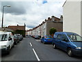
Kingswood : Moravian Road
Moravian Road just off of Hanham Road in Kingswood.
Image: © Lewis Clarke
Taken: 1 Feb 2013
0.22 miles
7
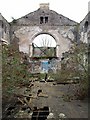
Kingswood Wesleyan Chapel
The building, listed grade II, is not in a good state. Built in 1843, it is described at http://www.imagesofengland.org.uk/Details/Default.aspx?id=28707&mode=adv . Buddleia is the principal tenant. According to http://derelictmisc.org.uk/wesley.html , which gives further images, it was a dance school after being desconsecrated. You'd be unwise to try dancing here at the moment.
Image: © Derek Harper
Taken: 26 Mar 2010
0.22 miles
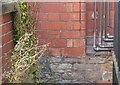
8
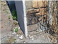
Ordnance Survey Cut Mark
This OS cut mark can be found on the No99 Hanham Road. It marks a point 110.338m above mean sea level.
Image: © Adrian Dust
Taken: 19 Jul 2021
0.22 miles
9

The road may be closed but the box will be open
A George V postbox by Carron on Hanham Road, just outside the old Douglas Motorcycle factory.
Image: © Neil Owen
Taken: 29 May 2024
0.23 miles
10
Ordnance Survey Cut Mark
This OS cut mark can be found on the old Motor Bike Works, Hanham Road. It marks a point 112.005m above mean sea level.
Image: © Adrian Dust
Taken: 19 Jul 2021
0.23 miles