IMAGES TAKEN NEAR TO
Stanley Road, BRISTOL, BS15 4PP
Introduction
This page details the photographs taken nearby to Stanley Road, BS15 4PP by members of the Geograph project.
The Geograph project started in 2005 with the aim of publishing, organising and preserving representative images for every square kilometre of Great Britain, Ireland and the Isle of Man.

There are currently over 7.5m images from over14,400 individuals and you can help contribute to the project by visiting https://www.geograph.org.uk
Image Map (Loading...)


Getting Data...Please wait
Leaflet Map data © OpenStreetMap
Images are licensed for reuse under creativecommons.org/licenses/by-sa/2.0
Notes
- Clicking on the map will re-center to the selected point.
- The higher the marker number, the further away the image location is from the centre of the postcode.
Image Listing (63 Images Found)
Images are licensed for reuse under creativecommons.org/licenses/by-sa/2.0
Image
Details
Distance
1
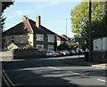
2009 : A4175 Stanley Road at Warmley
Joins the A420 immediately behind the camera position.
In this direction the A4175 passes over Siston Common, skirts around New Cheltenham and ends at Staple Hill, probably because it runs out of things to do.
Image: © Maurice Pullin
Taken: 12 Oct 2009
0.03 miles
2
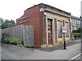
Warmley: Former National Westminster Bank
The building, at 17 High Street, is currently nothing more than an empty shell, but the words "National Westminster Bank" can just about be picked out as stain marks on the main stone beam above the door and windows. A quick search of the minutes of a local Siston Parish Council meeting show that the bank was built in 1937, and that in 2010 a planning application was submitted proposing the construction of five flats on the site, but presumably utilizing the old bank frontage.
Image: © Nigel Cox
Taken: 25 Jun 2011
0.04 miles
3
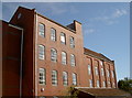
The old mill in Chapel Lane
This large redbrick building was originally a cornmill, built in 1907 for W. A. Brain and Son, served by the railway line beside it. The firm went through a few changes before becoming part of Spillers. It is now used as offices for a construction firm.
Image: © Neil Owen
Taken: 26 Sep 2018
0.05 miles
4

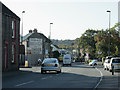
Stanley Road at the junction of London Road
Image: © David Howard
Taken: 1 Jun 2019
0.05 miles
6
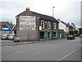
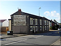
Warmley: Webb's of Warmley and the A420 High Street
The old painted sign on the wall may appear to be a relic of a bygone age, but it is pleasing to relate that the shop is Webb's of Warmley, the local cycle dealers. The road is the A420 looking towards Bristol.
Image: © Nigel Cox
Taken: 25 Jun 2011
0.05 miles
7
2009 : A420 High Street, Warmley
Tower Road to the left, Stanley Road to the right, up the hill to Kingswood straight on.
The advertisement is for Raleigh and Humber bicycles.
Image: © Maurice Pullin
Taken: 12 Oct 2009
0.05 miles
8
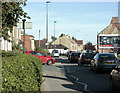
2009 : A420 at Warmley heading east
Tower Road North heads off to the right for Cadbury Heath and Oldland. The red car is trying to emerge from the A4175, Stanley Road but the A420 carries on regardless to Brideyate, Wick and eventually Chippenham.
Image: © Maurice Pullin
Taken: 12 Oct 2009
0.05 miles
9
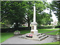
Warmley: The War Memorial
Set in the centre of the Memorial Gardens, Warmley's War Memorial is a Grade II Listed Structure.
Image: © Nigel Cox
Taken: 25 Jun 2011
0.05 miles
10

Humber and Raleigh Old Advertisement
Found on the A420 corner of Tower Road North, Warmley, Bristol, and still in good condition in April 2018
Image: © Rick Crowley
Taken: 15 Oct 2011
0.06 miles