IMAGES TAKEN NEAR TO
Siston Common, BRISTOL, BS15 4NY
Introduction
This page details the photographs taken nearby to Siston Common, BS15 4NY by members of the Geograph project.
The Geograph project started in 2005 with the aim of publishing, organising and preserving representative images for every square kilometre of Great Britain, Ireland and the Isle of Man.

There are currently over 7.5m images from over14,400 individuals and you can help contribute to the project by visiting https://www.geograph.org.uk
Image Map (Loading...)


Getting Data...Please wait
Leaflet Map data © OpenStreetMap
Images are licensed for reuse under creativecommons.org/licenses/by-sa/2.0
Notes
- Clicking on the map will re-center to the selected point.
- The higher the marker number, the further away the image location is from the centre of the postcode.
Image Listing (38 Images Found)
Images are licensed for reuse under creativecommons.org/licenses/by-sa/2.0
Image
Details
Distance
1
A cattle grid on a cycle path
Yes, a small cattle grid has been installed on the old Mangotsfield and Bath railway line, now converted into a popular cycle path. Quite why it was put there is not clear, but leaving the gate open so that anyone can bypass it is less so.
Image: © Neil Owen
Taken: 26 Sep 2018
0.03 miles
2
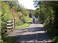
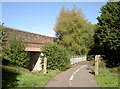
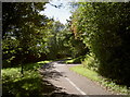
Siston Common Bridge
Siston Hill road passes under the former Mangotsfield to Bath branch line, now a cycle path
Image: © Andy Stone
Taken: 20 Jun 2012
0.04 miles
3
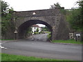
Old bridge on Siston Common
The old Mangotsfield and Bath line fell silent many years ago, but the bridge at the junction of Siston Hill and Stanley Road remains.
Image: © Neil Owen
Taken: 26 Sep 2018
0.05 miles
4
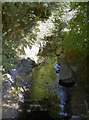
The Warmley Brook
Heading east to become the Siston Brook.
Image: © Neil Owen
Taken: 26 Sep 2018
0.05 miles
5
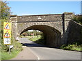
Two bridges over the brook
The Warmley Brook is crossed by a footbridge and a significant road bridge.
Image: © Neil Owen
Taken: 26 Sep 2018
0.06 miles
6
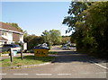
Firework Close
This little modern suburban road looks largely post-WWII in date. The name refers to, initially, a firework factory that was sited nearby around the turn of the 1900s. (The local area was rife with collieries at that time, so perhaps it is logical for it to be in the area.) Having closed, some of the associated buildings were taken over as a farm (known as Firework Farm, no less!); that too went with the expansion of this part of Siston, leaving us with the current scene. As a teasing footnote, off Firework Close is Fawkes Close.
Image: © Neil Owen
Taken: 26 Sep 2018
0.07 miles
7
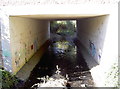
Water is no barrier
To the spray can brigade, at least. The Warmley Brook is not exactly in full spate, which may help.
Image: © Neil Owen
Taken: 26 Sep 2018
0.07 miles
8
Cows, not horses?
The old Dramway used to have horse-drawn carriages that took coal from the local collieries to the River Avon, several miles to the south. Today, the route is partly employed as a cycle path, but Siston Common is frequently bounded by some traditional cattle grids. You even find them on the cycle path in places too.
Image: © Neil Owen
Taken: 26 Sep 2018
0.08 miles
9
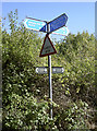
Shared path near the A4174
With the A4174 ring road very close to this part of Siston, there are plenty of shared paths for the use.
Image: © Neil Owen
Taken: 26 Sep 2018
0.10 miles
10
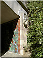
Motifs and foliage
Sadly overshadowed by the encroaching greenery, the intriguing roundel is awkward to see. Inside the bridge tunnel is lined with tiles with images of more greenery.
Image: © Neil Owen
Taken: 26 Sep 2018
0.11 miles