IMAGES TAKEN NEAR TO
Lynton, BRISTOL, BS15 4JY
Introduction
This page details the photographs taken nearby to Lynton, BS15 4JY by members of the Geograph project.
The Geograph project started in 2005 with the aim of publishing, organising and preserving representative images for every square kilometre of Great Britain, Ireland and the Isle of Man.

There are currently over 7.5m images from over14,400 individuals and you can help contribute to the project by visiting https://www.geograph.org.uk
Image Map
Images are licensed for reuse under creativecommons.org/licenses/by-sa/2.0
Notes
- Clicking on the map will re-center to the selected point.
- The higher the marker number, the further away the image location is from the centre of the postcode.
Image Listing (19 Images Found)
Images are licensed for reuse under creativecommons.org/licenses/by-sa/2.0
Image
Details
Distance
1
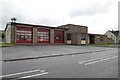
Kingswood Fire Station
Kingswood Fire Station, Tenniscourt Road, Bristol is station number 10 of Avon Fire & Rescue Service
Image: © Kevin Hale
Taken: 8 May 2006
0.11 miles
2
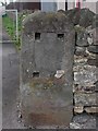
Old Milestone by the A420, Hill Street, Kingswood
Stone post (plate lost) by the A420, in parish of Kingswood (South Gloucestershire District), Hill Street, Kingswood, by No. 103, at end of wall, on North side of road. Bristol incised iron plate, erected by the Bristol turnpike trust in the 19th century.
Inscription once read:-
(Bristol)
(4)
Milestone Society National ID: GL_BRCP04
Image: © M Faherty
Taken: 7 Apr 2010
0.19 miles
3
Hill Street milestone
It is natural to see an old stone with the plate missing - many have doubtless been melted down as scrap by the unscrupulous. It had marked Bristol as being four miles away. This one is on Hill Street in Kingswood, close to a lane which was created along with the modern housing beside it.
Image: © Neil Owen
Taken: 4 Jul 2024
0.19 miles
4
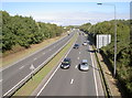
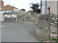
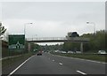
The A4174 through Siston
Built in the early 2000s, this major arterial route takes in most of the eastern side of Bristol.
Image: © Neil Owen
Taken: 26 Sep 2018
0.19 miles
5
Footbridge near Deanery Road Roundabout
This footbridge crosses Bristol's ringroad to the north of Deanery Road Roundabout.
Image: © Ruth Riddle
Taken: 4 May 2012
0.20 miles
6
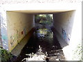
Water is no barrier
To the spray can brigade, at least. The Warmley Brook is not exactly in full spate, which may help.
Image: © Neil Owen
Taken: 26 Sep 2018
0.20 miles
7
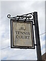
The Tennis Court sign
As faded as the pub itself, the inn has been converted into residential use.
Image: © Neil Owen
Taken: 4 Jul 2024
0.21 miles
8
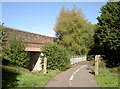
Two bridges over the brook
The Warmley Brook is crossed by a footbridge and a significant road bridge.
Image: © Neil Owen
Taken: 26 Sep 2018
0.21 miles
9
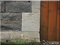
Fading away on the Tennis Court Inn
As the fortunes of the old pub have fallen, so has a benchmark on it. Now barely discernible, the mark is listed in the Benchmark Database: https://www.bench-marks.org.uk/bm113050.
Image: © Neil Owen
Taken: 4 Jul 2024
0.22 miles
10
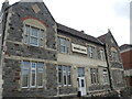
The Tennis Court
Once a busy pub on the outskirts of the main road through Kingswood and Warmley, the Tennis Court closed in August 2016, and was converted into residential use.
It was once the haunt of some of the notorious Cock Road gang of the nineteenth century. Reports regard an incident in November 1824, seven members of the gang, including Mark Whiting and James Caines, were drinking in the Tennis Court Inn when Isaac Gorden came in. After a hostile exchange of words, Gorden was later found close by having been beaten and stabbed to death. Six members of the gang were tried for murder at the Gloucester Assizes in April 1825. All were acquitted except Mark Whiting and James Caines, who were hanged.
Image: © Neil Owen
Taken: 4 Jul 2024
0.22 miles