IMAGES TAKEN NEAR TO
Hill Street, BRISTOL, BS15 4EP
Introduction
This page details the photographs taken nearby to Hill Street, BS15 4EP by members of the Geograph project.
The Geograph project started in 2005 with the aim of publishing, organising and preserving representative images for every square kilometre of Great Britain, Ireland and the Isle of Man.

There are currently over 7.5m images from over14,400 individuals and you can help contribute to the project by visiting https://www.geograph.org.uk
Image Map
Images are licensed for reuse under creativecommons.org/licenses/by-sa/2.0
Notes
- Clicking on the map will re-center to the selected point.
- The higher the marker number, the further away the image location is from the centre of the postcode.
Image Listing (25 Images Found)
Images are licensed for reuse under creativecommons.org/licenses/by-sa/2.0
Image
Details
Distance
1
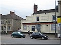
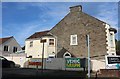
Kingswood: The former Highwayman
In 2011 the A420 road heading into Bristol was littered with dead pubs. This former Ansells outlet is one of them. This is the view from Honeyhill Road.
Image: © Nigel Cox
Taken: 25 Jun 2011
0.02 miles
2
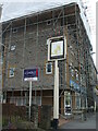
A sign is all that's left
The large residential block is called Highwayman Court - a modern development on the site of the former Ansell's pub, The Highwayman. A fixture for many years in Kingswood, the pub closed in 2010, was demolished, and the offices and flats opened by 2015. All that remains is the old pub sign, now hanging forlornly and ghostly.
Image: © Neil Owen
Taken: 29 May 2024
0.02 miles
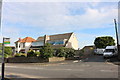
4
2009 : A420 Hill Street, looking west up Warmley Hill
Kingswood begins at the top of the hill.
Image: © Maurice Pullin
Taken: 12 Oct 2009
0.03 miles
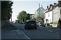
5
Honey Hill Road at the corner of High Street, Warmley
Image: © David Howard
Taken: 1 Jun 2019
0.03 miles
7
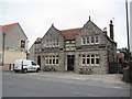
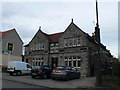
Kingswood: The Old Flowerpot Inn 1890
This late Victorian public house on the A420 High Street / Hill Street has an attractive name plate set over the front door with symmetrical gable ends on either side. Comparing this image with Eirian's from February 2011 Image it is evident that the white van has only shuffled a few paces along the pub frontage to the left since!
Image: © Nigel Cox
Taken: 25 Jun 2011
0.05 miles
8
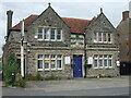
Not gone to pot
The Flowerpot is dated 1890 and was one of several pubs on this part of Kingswood's main road. However, times have changed, lots of old pubs have either been demolished and replaced or converted into residential use. The Flowerpot was closed in 2017, with a concerted effort to convert it into a child care nursery loudly condemned by locals. Despite that planning being granted consent, it has not happened and the old pub has now been taken over by Sri Guru Hargobind Sahib Gurmat Vidhyala (Bristol), formerly known as Bristol Gurmat Class. The Sikh organisation is looking to create a community facility and learning centre.
Image: © Neil Owen
Taken: 29 May 2024
0.05 miles
9
The Old Flowerpot Inn, Kingswood, Bristol
Image: © Eirian Evans
Taken: 16 Feb 2011
0.06 miles
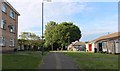
10
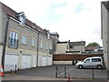
Station Court
Now modern housing, this was the spot where the old police station stood as Kingswood grew notably around the turn of the 1900s.
Image: © Neil Owen
Taken: 4 Jul 2024
0.07 miles