IMAGES TAKEN NEAR TO
Alma Close, BRISTOL, BS15 4EL
Introduction
This page details the photographs taken nearby to Alma Close, BS15 4EL by members of the Geograph project.
The Geograph project started in 2005 with the aim of publishing, organising and preserving representative images for every square kilometre of Great Britain, Ireland and the Isle of Man.

There are currently over 7.5m images from over14,400 individuals and you can help contribute to the project by visiting https://www.geograph.org.uk
Image Map (Loading...)


Getting Data...Please wait
Leaflet Map data © OpenStreetMap
Images are licensed for reuse under creativecommons.org/licenses/by-sa/2.0
Notes
- Clicking on the map will re-center to the selected point.
- The higher the marker number, the further away the image location is from the centre of the postcode.
Image Listing (47 Images Found)
Images are licensed for reuse under creativecommons.org/licenses/by-sa/2.0
Image
Details
Distance
1
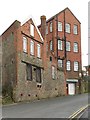
Kingsgate House, Kingswood
On Church Road, this C19 red brick and stone factory building consists of two adjoining blocks. Many thanks to John M for pointing out that it is shown on old maps as a Boot and Shoe Factory. It now contains a Furniture Project organisation and a training firm.
Image: © Derek Harper
Taken: 26 Mar 2010
0.09 miles
2
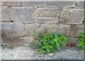
Ordnance Survey Cut Mark
This OS cut mark can be found on the NW angle of the Engineering Works on Church Road. It marks a point 101.867m above mean sea level.
Image: © Adrian Dust
Taken: 19 Jul 2021
0.10 miles
3
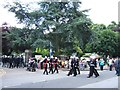
Entrance to Kingswood Park
Part of the 2010 Armed Forces Day parade turning from High Street into the main entrance of Kingswood Park.
Image: © Ruth Riddle
Taken: 26 Jun 2010
0.13 miles
4
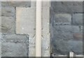
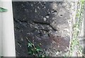
Benchmark hiding on the old school
A cutmark, as listed in the Benchmark Database: https://www.bench-marks.org.uk/bm84825 , is behind a drainpipe on what is now The Park Centre - previously a school. See Image] for a wider view.
Image: © Neil Owen
Taken: 29 May 2024
0.13 miles
5
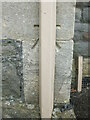
Ordnance Survey Cut Mark
This OS cut mark can be found on the NW angle of the school on High Street. It marks a point 105.625m above mean sea level.
Image: © Adrian Dust
Taken: 19 Jul 2021
0.13 miles
6
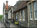
The Park Centre, Kingswood
Formerly the school, it has been operating as a community centre for about twenty years now. There is a benchmark right on the corner - see Image
Image: © Neil Owen
Taken: 29 May 2024
0.13 miles
7
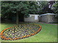
Flowers by the block
Kingswood Park is hoped to be undergoing some significant improvements in the future. Plans have been made public that, amongst many points, the public toilet block in the background will be converted into a maintenance unit; a new toilet facility will be built by the tennis courts.
Image: © Neil Owen
Taken: 4 Jul 2024
0.14 miles
8
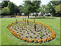
Floral display in Kingswood Park
One of several patches given some special treatment and awaiting some more typical summer weather to really show.
Image: © Neil Owen
Taken: 4 Jul 2024
0.15 miles
9
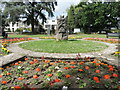
Central arrangement in Kingswood Park
Visitors using the High Street entrance will be greeted with the larger of the flower displays. In the centre is a carved tree trunk, created in 2014. Recent attempts to renovate the park have been published and it is hoped that the work will start soon.
Image: © Neil Owen
Taken: 4 Jul 2024
0.15 miles
10
Ordnance Survey Cut Mark
This damaged OS cut mark can be found on a buttress of Holy Trinity Church. It marks a point 108.829m above mean sea level.
Image: © Adrian Dust
Taken: 19 Jul 2021
0.16 miles