IMAGES TAKEN NEAR TO
Alma Road, BRISTOL, BS15 4EH
Introduction
This page details the photographs taken nearby to Alma Road, BS15 4EH by members of the Geograph project.
The Geograph project started in 2005 with the aim of publishing, organising and preserving representative images for every square kilometre of Great Britain, Ireland and the Isle of Man.

There are currently over 7.5m images from over14,400 individuals and you can help contribute to the project by visiting https://www.geograph.org.uk
Image Map (Loading...)


Getting Data...Please wait
Leaflet Map data © OpenStreetMap
Images are licensed for reuse under creativecommons.org/licenses/by-sa/2.0
Notes
- Clicking on the map will re-center to the selected point.
- The higher the marker number, the further away the image location is from the centre of the postcode.
Image Listing (38 Images Found)
Images are licensed for reuse under creativecommons.org/licenses/by-sa/2.0
Image
Details
Distance
1
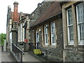
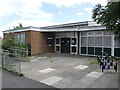
The Park Centre, Kingswood
Formerly the school, it has been operating as a community centre for about twenty years now. There is a benchmark right on the corner - see Image
Image: © Neil Owen
Taken: 29 May 2024
0.13 miles
2
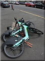
Taking the easy way
Some of the public hire electric bikes have had a long day already. Perhaps they need more than a quick charge.
Image: © Neil Owen
Taken: 4 Jul 2024
0.13 miles
3
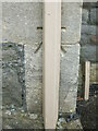
Benchmark hiding on the old school
A cutmark, as listed in the Benchmark Database: https://www.bench-marks.org.uk/bm84825 , is behind a drainpipe on what is now The Park Centre - previously a school. See Image] for a wider view.
Image: © Neil Owen
Taken: 29 May 2024
0.13 miles
4
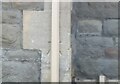
Ordnance Survey Cut Mark
This OS cut mark can be found on the NW angle of the school on High Street. It marks a point 105.625m above mean sea level.
Image: © Adrian Dust
Taken: 19 Jul 2021
0.13 miles
5
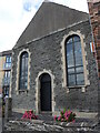
The end of the chapter
Kingswood library was based here for many years but was closed on 18th March, 2019. According to the council, moving the books to part of the Civic Centre just up the road will save some £430,000 per annum. What will happen to the old library is not known, but selling it off could raise more funds for the cash-strapped council.
Image: © Neil Owen
Taken: 4 Jul 2024
0.13 miles
6
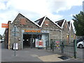
A different type of shop
Sainsbury's took over this old boot and shoe factory, which operated until after the war.
Image: © Neil Owen
Taken: 4 Jul 2024
0.13 miles
7
The roof is a give-away
Sainsbury's took over the old boot and shoe factory, but kept the integral fabric. Hence the north-facing roofline keeps the original appearance.
Image: © Neil Owen
Taken: 4 Jul 2024
0.14 miles
8
The old Primitive Methodist Chapel
Kingswood was a cradle of dissenting church-goers and this was once the Primitive branch of the Methodists in the area. These days it is used for warehousing. See Image] for a benchmark at the gatepost.
Image: © Neil Owen
Taken: 4 Jul 2024
0.16 miles
9
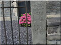
Benchmark on the gatepost of the old chapel
A cutmark, as listed in the Benchmark Database: https://www.bench-marks.org.uk/bm84826 , on the gatepost of the old Methodist Chapel on High Street. The chapel is now in commercial use. See Image] for a wider view.
Image: © Neil Owen
Taken: 4 Jul 2024
0.16 miles
10
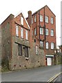
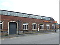
Kingsgate House, Kingswood
On Church Road, this C19 red brick and stone factory building consists of two adjoining blocks. Many thanks to John M for pointing out that it is shown on old maps as a Boot and Shoe Factory. It now contains a Furniture Project organisation and a training firm.
Image: © Derek Harper
Taken: 26 Mar 2010
0.16 miles