IMAGES TAKEN NEAR TO
Holly Crescent, BRISTOL, BS15 4EB
Introduction
This page details the photographs taken nearby to Holly Crescent, BS15 4EB by members of the Geograph project.
The Geograph project started in 2005 with the aim of publishing, organising and preserving representative images for every square kilometre of Great Britain, Ireland and the Isle of Man.

There are currently over 7.5m images from over14,400 individuals and you can help contribute to the project by visiting https://www.geograph.org.uk
Image Map (Loading...)


Getting Data...Please wait
Leaflet Map data © OpenStreetMap
Images are licensed for reuse under creativecommons.org/licenses/by-sa/2.0
Notes
- Clicking on the map will re-center to the selected point.
- The higher the marker number, the further away the image location is from the centre of the postcode.
Image Listing (23 Images Found)
Images are licensed for reuse under creativecommons.org/licenses/by-sa/2.0
Image
Details
Distance
1
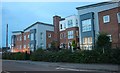
Falcon Court on New Cheltenham Road
It looks very industrial but is probably a lot nicer inside
Image: © David Howard
Taken: 1 Jun 2019
0.10 miles
2
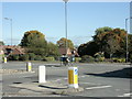
2009 : Mini roundabout, one of a pair in New Cheltenham
At the junction of five roads, Cheltenham Road twice, Spring Hill, Fry's Lees Hill and Church Road.
Image: © Maurice Pullin
Taken: 12 Oct 2009
0.15 miles
3
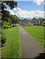
Path near Kingswood
Cross ing a small green open space to the east of the junction of Lees Hill and New Cheltenham Road. The houses are at the junction of the latter with Alma Road.
Image: © Derek Harper
Taken: 29 May 2015
0.15 miles
4
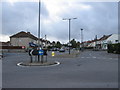
Two mini-roundabouts in close proximity
Image: © William Avery
Taken: 17 Sep 2006
0.16 miles
5
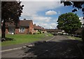
The Haven, Kingswood
On the other side of Lees Hill from Image, this is a rectangle of sheltered housing.
Image: © Derek Harper
Taken: 29 May 2015
0.17 miles
6
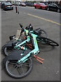
Taking the easy way
Some of the public hire electric bikes have had a long day already. Perhaps they need more than a quick charge.
Image: © Neil Owen
Taken: 4 Jul 2024
0.20 miles
7
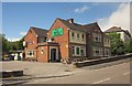
The Royal Archer, Kingswood
The pub is on Lees Hill, only a little way from the roundabouts shown in Image
Image: © Derek Harper
Taken: 29 May 2015
0.20 miles
8
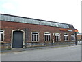
A different type of shop
Sainsbury's took over this old boot and shoe factory, which operated until after the war.
Image: © Neil Owen
Taken: 4 Jul 2024
0.21 miles
9
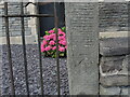
Benchmark on the gatepost of the old chapel
A cutmark, as listed in the Benchmark Database: https://www.bench-marks.org.uk/bm84826 , on the gatepost of the old Methodist Chapel on High Street. The chapel is now in commercial use. See Image] for a wider view.
Image: © Neil Owen
Taken: 4 Jul 2024
0.21 miles
10
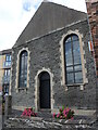
The old Primitive Methodist Chapel
Kingswood was a cradle of dissenting church-goers and this was once the Primitive branch of the Methodists in the area. These days it is used for warehousing. See Image] for a benchmark at the gatepost.
Image: © Neil Owen
Taken: 4 Jul 2024
0.21 miles