IMAGES TAKEN NEAR TO
Parklands, BRISTOL, BS15 4BW
Introduction
This page details the photographs taken nearby to Parklands, BS15 4BW by members of the Geograph project.
The Geograph project started in 2005 with the aim of publishing, organising and preserving representative images for every square kilometre of Great Britain, Ireland and the Isle of Man.

There are currently over 7.5m images from over14,400 individuals and you can help contribute to the project by visiting https://www.geograph.org.uk
Image Map
Images are licensed for reuse under creativecommons.org/licenses/by-sa/2.0
Notes
- Clicking on the map will re-center to the selected point.
- The higher the marker number, the further away the image location is from the centre of the postcode.
Image Listing (38 Images Found)
Images are licensed for reuse under creativecommons.org/licenses/by-sa/2.0
Image
Details
Distance
1
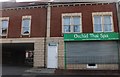
Orchid Thai Spa on High Street, Kingswood
Image: © David Howard
Taken: 1 Jun 2019
0.04 miles
2
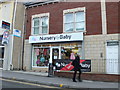
Nursery & Baby shop, on Hanham Road, Kingswood
Image: © Eirian Evans
Taken: 16 Feb 2011
0.04 miles
3
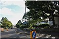
Kingswood : Cecil Road
Cecil Road at a pedestrian crossing on the junction with Regent Street and High Street.
Image: © Lewis Clarke
Taken: 1 Feb 2013
0.06 miles
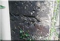
4
Ordnance Survey Cut Mark
This OS cut mark can be found on the club south side of Regent Street. It marks a point 112.570m above mean sea level.
Image: © Adrian Dust
Taken: 19 Jul 2021
0.06 miles
5
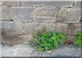
Ordnance Survey Cut Mark
This OS cut mark can be found on the NW angle of the Engineering Works on Church Road. It marks a point 101.867m above mean sea level.
Image: © Adrian Dust
Taken: 19 Jul 2021
0.08 miles
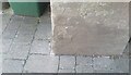
6
Ordnance Survey Cut Mark
This damaged OS cut mark can be found on a buttress of Holy Trinity Church. It marks a point 108.829m above mean sea level.
Image: © Adrian Dust
Taken: 19 Jul 2021
0.08 miles
7
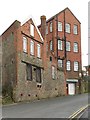
Kingsgate House, Kingswood
On Church Road, this C19 red brick and stone factory building consists of two adjoining blocks. Many thanks to John M for pointing out that it is shown on old maps as a Boot and Shoe Factory. It now contains a Furniture Project organisation and a training firm.
Image: © Derek Harper
Taken: 26 Mar 2010
0.08 miles
8
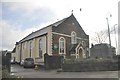
Kingswood : Kingswood Congregational Church
The church on Hanham Road in Kingswood.
Image: © Lewis Clarke
Taken: 1 Feb 2013
0.10 miles
9
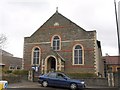
Congregational church, Kingswood
The church, accompanied by a hall on the left, is at the junction of Hanham Road and Cecil Road.
Image: © Derek Harper
Taken: 26 Mar 2010
0.10 miles