IMAGES TAKEN NEAR TO
Harefield Close, BRISTOL, BS15 3TD
Introduction
This page details the photographs taken nearby to Harefield Close, BS15 3TD by members of the Geograph project.
The Geograph project started in 2005 with the aim of publishing, organising and preserving representative images for every square kilometre of Great Britain, Ireland and the Isle of Man.

There are currently over 7.5m images from over14,400 individuals and you can help contribute to the project by visiting https://www.geograph.org.uk
Image Map
Images are licensed for reuse under creativecommons.org/licenses/by-sa/2.0
Notes
- Clicking on the map will re-center to the selected point.
- The higher the marker number, the further away the image location is from the centre of the postcode.
Image Listing (22 Images Found)
Images are licensed for reuse under creativecommons.org/licenses/by-sa/2.0
Image
Details
Distance
1
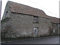
Castle Hill Farm, outbuilding
The building carries a cut bench mark on the left-hand post of the doorway. See http://www.geograph.org.uk/photo/2903299 for a close-up.
Image: © Brian Westlake
Taken: 17 Mar 2012
0.08 miles
2
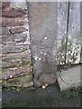
Cut Mark: Hanham Green, Castle Inn Farm
Cut mark on a farm outbuilding (see http://www.geograph.org.uk/photo/2903279 ). See http://www.bench-marks.org.uk/bm42583 for details.
Image: © Brian Westlake
Taken: 17 Mar 2012
0.08 miles
3
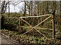
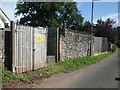
Barred gate at The Batch
Old iron at a rather neglected entrance.
Image: © Neil Owen
Taken: 20 Feb 2018
0.13 miles
4
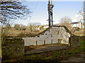
Half a building at The Batch
The little car park includes a rather odd and incomplete building.
Image: © Neil Owen
Taken: 20 Feb 2018
0.13 miles
5
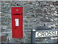
Victorian box at Hanham Cross
An old post box with a touch of gold paint to crown it all.
Image: © Neil Owen
Taken: 30 Jul 2020
0.14 miles
6
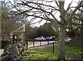
Bickley Wood car park
The River Avon is home to a wide range of habitats and environments. A small car park is provided for visitors to Castle Farm Road, allowing them to explore the many paths around the Local Nature Reserve.
Image: © Neil Owen
Taken: 20 Feb 2018
0.15 miles
7
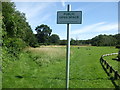
Hanham Green, a public open space
The sign says so.
Image: © Neil Owen
Taken: 30 Jul 2020
0.15 miles
8
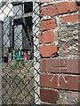
Benchmark in Crossleaze Road
An electricity sub-station also bears a benchmark. See Image] for a wider view and https://www.bench-marks.org.uk/bm130060 for the entry in the Benchmark Database.
Image: © Neil Owen
Taken: 30 Jul 2020
0.17 miles
9
Sub-station in Crossleaze Road
A small installation along the minor road in Conham, with a benchmark on its far wall edge - see Image
Image: © Neil Owen
Taken: 30 Jul 2020
0.17 miles
10
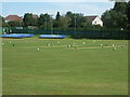
Hanham Cricket ground
No slips but plenty of gull-ies.
Image: © Neil Owen
Taken: 30 Jul 2020
0.18 miles