IMAGES TAKEN NEAR TO
Greenbank Road, BRISTOL, BS15 3SD
Introduction
This page details the photographs taken nearby to Greenbank Road, BS15 3SD by members of the Geograph project.
The Geograph project started in 2005 with the aim of publishing, organising and preserving representative images for every square kilometre of Great Britain, Ireland and the Isle of Man.

There are currently over 7.5m images from over14,400 individuals and you can help contribute to the project by visiting https://www.geograph.org.uk
Image Map
Images are licensed for reuse under creativecommons.org/licenses/by-sa/2.0
Notes
- Clicking on the map will re-center to the selected point.
- The higher the marker number, the further away the image location is from the centre of the postcode.
Image Listing (25 Images Found)
Images are licensed for reuse under creativecommons.org/licenses/by-sa/2.0
Image
Details
Distance
1
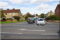
Greenbank Road
A residential road off the A431.
Image: © Bill Boaden
Taken: 28 Sep 2017
0.06 miles
2
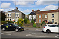
Cottages on Stonehill
Slightly older buildings than a lot of the surrounding suburbia.
Image: © Bill Boaden
Taken: 28 Sep 2017
0.06 miles
3
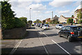
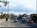
Traffic on Stonehill
The traffic is moving slowly on the A431 approaching Hanham.
Image: © Bill Boaden
Taken: 28 Sep 2017
0.08 miles
4
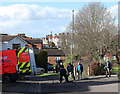
2011 : Dynorod men on an errand of mercy
The houses in the background are on High Street, Hanham.
Image: © Maurice Pullin
Taken: 14 Feb 2011
0.13 miles
5
2011 : A431 between Hanham High Street and Stonehill
The no entry sign is at the end of Whittucks Road, beyond that is the Blue Bowl inn.
The A431 to Longwell Green and Bath crosses the East Bristol bypass at the top of the next hill.
Image: © Maurice Pullin
Taken: 14 Feb 2011
0.13 miles
6
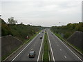
Stone Hill, ring road
A4174, looking towards Oldland.
Image: © Mike Faherty
Taken: 8 Oct 2010
0.14 miles
7
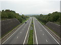
Stone Hill, ring road
A4174, looking towards Hanham Green.
Image: © Mike Faherty
Taken: 8 Oct 2010
0.14 miles
8
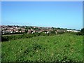
View towards Recreation Ground Hanham
View north from hill above Mount Pleasant Farm towards the recreation ground in Hanham across the ring road (hidden by slope). To the right is the Aspects Retail Development
Image: © Damon Knight
Taken: 24 Aug 2007
0.14 miles
9
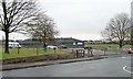
AEK - Boco Football Club, Greenbank Road
Formed when two older clubs joined forces in 2003. With 500 children on the books, as well as six adult teams.
Image: © Christine Johnstone
Taken: 23 Mar 2013
0.15 miles
10
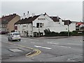
The Blue Bowl, Hanham
At the junction of High Street and Whittucks Road.
Image: © Christine Johnstone
Taken: 23 Mar 2013
0.16 miles