IMAGES TAKEN NEAR TO
Grange Avenue, BRISTOL, BS15 3PF
Introduction
This page details the photographs taken nearby to Grange Avenue, BS15 3PF by members of the Geograph project.
The Geograph project started in 2005 with the aim of publishing, organising and preserving representative images for every square kilometre of Great Britain, Ireland and the Isle of Man.

There are currently over 7.5m images from over14,400 individuals and you can help contribute to the project by visiting https://www.geograph.org.uk
Image Map
Images are licensed for reuse under creativecommons.org/licenses/by-sa/2.0
Notes
- Clicking on the map will re-center to the selected point.
- The higher the marker number, the further away the image location is from the centre of the postcode.
Image Listing (24 Images Found)
Images are licensed for reuse under creativecommons.org/licenses/by-sa/2.0
Image
Details
Distance
1
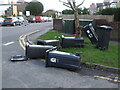
You can tell it's a windy day
Rubbish bins, skittled by the gale. This occurs after they have been emptied, and many a recycling box has scuttled down the hill.
Image: © Neil Owen
Taken: 23 Feb 2021
0.06 miles
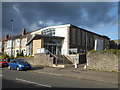
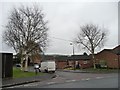
4
2011 : Hanham Baptist Church, High Street, Hanham
The first Baptist church met in Spitalfields, London in 1612.
Baptists were present in Hanham in 1658 when persecution forced them to hold secret meetings in Hanham Woods. The Act of Toleration was passed in 1689, and in 1714 the first building was erected on this site.
Information from: http://www.baptist.org.uk/baptist_life/baptist_history.html and http://www.hanhambaptistchurch.com/
Image: © Maurice Pullin
Taken: 14 Feb 2011
0.10 miles
5
Silver birch on Whittucks Close
Looking east from the junction with Whittucks Road.
Image: © Christine Johnstone
Taken: 23 Mar 2013
0.11 miles
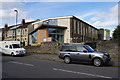
6
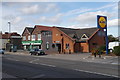
Bank and pharmacy in Hanham
The branch of NatWest is becoming an increasingly rare sight as the bank has embarked on a rationalisation programme.
Image: © Bill Boaden
Taken: 28 Sep 2017
0.11 miles
7
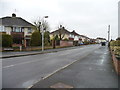
Abbots Avenue, Hanham
Looking westwards from the junction with Whittucks Road.
Image: © Christine Johnstone
Taken: 23 Mar 2013
0.11 miles
8
Whittucks Road meets the A431
Image: © Derek Harper
Taken: 13 Jul 2013
0.12 miles
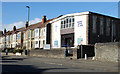
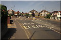
9
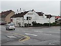
The Blue Bowl, Hanham
At the junction of High Street and Whittucks Road.
Image: © Christine Johnstone
Taken: 23 Mar 2013
0.13 miles
10
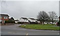
White houses in The Meadows
A 1990s housing development east of Whittucks Road.
Image: © Christine Johnstone
Taken: 23 Mar 2013
0.14 miles