IMAGES TAKEN NEAR TO
Samuel White Road, BRISTOL, BS15 3LZ
Introduction
This page details the photographs taken nearby to Samuel White Road, BS15 3LZ by members of the Geograph project.
The Geograph project started in 2005 with the aim of publishing, organising and preserving representative images for every square kilometre of Great Britain, Ireland and the Isle of Man.

There are currently over 7.5m images from over14,400 individuals and you can help contribute to the project by visiting https://www.geograph.org.uk
Image Map (Loading...)


Getting Data...Please wait
Leaflet Map data © OpenStreetMap
Images are licensed for reuse under creativecommons.org/licenses/by-sa/2.0
Notes
- Clicking on the map will re-center to the selected point.
- The higher the marker number, the further away the image location is from the centre of the postcode.
Image Listing (14 Images Found)
Images are licensed for reuse under creativecommons.org/licenses/by-sa/2.0
Image
Details
Distance
1
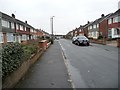
Samuel White Road, Hanham
Running parallel to, and east of, Whittucks Road. Samuel White appears to have been a local Victorian landowner.
Image: © Christine Johnstone
Taken: 23 Mar 2013
0.03 miles
2
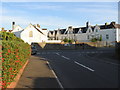
Forest Edge, Hanham
Looking westwards from the junction with Whittucks Road.
Image: © Christine Johnstone
Taken: 23 Mar 2013
0.08 miles
3
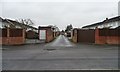
Back lane, Hanham
Running behind the gardens of Whittucks Road [left / east] and Samuael White Road [right / east].
Image: © Christine Johnstone
Taken: 23 Mar 2013
0.09 miles
4
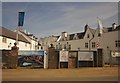
Hanham Hall from the north-west
The site includes a 1600s Grade 2* listed house, which became part of a mental hospital in 1916. Barratts are now redeveloping it for housing.
Image: © Christine Johnstone
Taken: 23 Mar 2013
0.10 miles
5
Hanham Hall
A similar view to Image The building is originally C16 and is described at http://list.english-heritage.org.uk/resultsingle.aspx?uid=1278348&searchtype=mapsearch . "Large rambling house with "A" plan and long wing to north." I wonder if the developers will restore the ashlar facing on the gatepost?
Image: © Derek Harper
Taken: 13 Jul 2013
0.10 miles
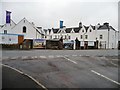
6
Hanham Hospital
This hospital is closed.
Image: © William Avery
Taken: 23 Sep 2006
0.10 miles
7
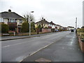
Abbots Avenue, Hanham
Looking westwards from the junction with Whittucks Road.
Image: © Christine Johnstone
Taken: 23 Mar 2013
0.14 miles
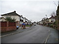
8
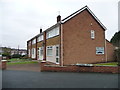
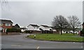
Houses on Samuel White Road
At the eastern junction with Lydiard Croft.
Image: © Christine Johnstone
Taken: 23 Mar 2013
0.16 miles
9
White houses in The Meadows
A 1990s housing development east of Whittucks Road.
Image: © Christine Johnstone
Taken: 23 Mar 2013
0.18 miles
10
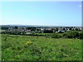
Hanham Hospital and Hanham Hall Farm
View from the hill above Mount Pleasant Farm NW across the ring road (obscured by the slope). Hospital is to the right, farm to the left
Image: © Damon Knight
Taken: 24 Aug 2007
0.19 miles